
Carte topographique Nansana
Carte interactive
Cliquez sur la carte pour afficher l’altitude.
Nansana
Nansana is located on the main highway between Kampala and Hoima, the Kampala-Hoima Road. The town is located approximately 12 kilometres (7 mi), by road, north-west of Kampala, Uganda's capital and largest city. This is approximately 8 kilometres (5 mi), by road, south of Wakiso, the location of the district headquarters. The coordinates of the town are 0°21'50.0"N, 32°31'43.0"E (Latitude:0.363889; Longitude:32.528611). Nansana sits at an average elevation of 1,191 metres (3,907 ft), above mean sea level.
À propos de cette carte
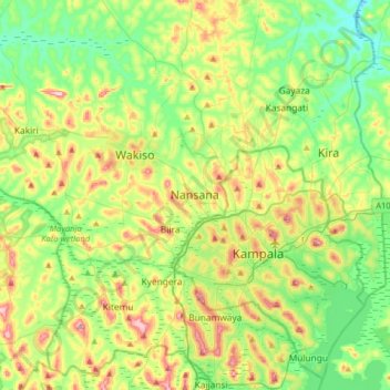
Nom : Carte topographique Nansana, altitude, relief.
Lieu : Nansana, Wakiso, Central Region, Uganda (0.20582 32.36923 0.52582 32.68923)
Altitude moyenne : 1 172 m
Altitude minimum : 1 093 m
Altitude maximum : 1 324 m