
Carte topographique Thierbach
Carte interactive
Cliquez sur la carte pour afficher l’altitude.
À propos de cette carte
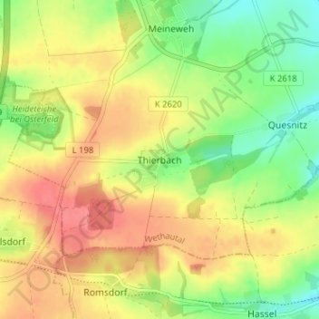
Nom : Carte topographique Thierbach, altitude, relief.
Altitude moyenne : 275 m
Altitude minimum : 239 m
Altitude maximum : 308 m
Autres cartes topographiques
Cliquez sur une carte pour visualiser sa topographie, son altitude et son relief.
Karsdorf
Duitsland > Saksen-Anhalt > Burgenlandkreis
Karsdorf, Unstruttal, Burgenlandkreis, Saksen-Anhalt, 06638, Duitsland
Altitude moyenne : 170 m
Bad Bibra
Duitsland > Saksen-Anhalt > Burgenlandkreis
Bad Bibra, An der Finne, Burgenlandkreis, Saksen-Anhalt, Duitsland
Altitude moyenne : 230 m
Osterfeld
Duitsland > Saksen-Anhalt > Burgenlandkreis > Osterfeld > Osterfeld
Osterfeld, Wethautal, Burgenlandkreis, Saksen-Anhalt, 06721, Duitsland
Altitude moyenne : 238 m