
Carte topographique Mayo-Belwa
Carte interactive
Cliquez sur la carte pour afficher l’altitude.
À propos de cette carte
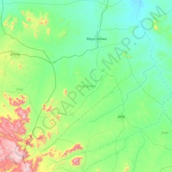
Nom : Carte topographique Mayo-Belwa, altitude, relief.
Lieu : Mayo-Belwa, Adamawa State, Nigeria (8.54623 11.69494 9.19513 12.19691)
Altitude moyenne : 446 m
Altitude minimum : 185 m
Altitude maximum : 1 538 m
The rainy season in Mayo-Belwa is oppressive and overcast, the dry season is partly cloudy, and it is hot all year. Throughout the year, the temperature normally ranges from 61°F to 99°F, with temperatures rarely falling below 55°F or rising above 105°F. Mayo Belwa has a Tropical wet and dry or savanna climate (Classification: Aw) and is located at an elevation of None meters (0 feet) above sea level. The yearly temperature in the district is 30.37oC (86.67oF), which is 0.91% higher than the national average. Mayo Belwa gets about 113.75 millimeters (4.48 inches) of rain every year and has 136.05 wet days (37.27% of the time).
Autres cartes topographiques
Cliquez sur une carte pour visualiser sa topographie, son altitude et son relief.
Leprosy Village
Nigeria > Adamawa State > Michika
Leprosy Village, Michika, Adamawa State, Nigeria
Altitude moyenne : 478 m
Mubi
Nigeria > Adamawa State > Mubi North
Mubi, Mubi North, Adamawa State, Nigeria
Altitude moyenne : 639 m
Maya Belwa
Nigeria > Adamawa State > Mayo-Belwa
Maya Belwa, Mayo-Belwa, Adamawa State, Nigeria
Altitude moyenne : 278 m
Lafia
Nigeria > Adamawa State > Larmurde
Lafia, Larmurde, Adamawa State, Nigeria
Altitude moyenne : 311 m