
Carte topographique Silecroft
Carte interactive
Cliquez sur la carte pour afficher l’altitude.
À propos de cette carte
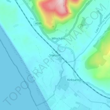
Nom : Carte topographique Silecroft, altitude, relief.
Lieu : Silecroft, Cumberland, England, LA18 4NR, United Kingdom (54.20487 -3.35542 54.24487 -3.31542)
Altitude moyenne : 44 m
Altitude minimum : 0 m
Altitude maximum : 356 m
Autres cartes topographiques
Cliquez sur une carte pour visualiser sa topographie, son altitude et son relief.
Milton
United Kingdom > England > Cumberland > Brampton
Milton, Brampton, Cumberland, England, CA8 1HX, United Kingdom
Altitude moyenne : 139 m