
Carte topographique Herxheim
Carte interactive
Cliquez sur la carte pour afficher l’altitude.
À propos de cette carte
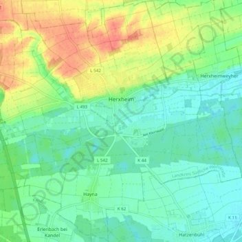
Nom : Carte topographique Herxheim, altitude, relief.
Altitude moyenne : 130 m
Altitude minimum : 112 m
Altitude maximum : 162 m
Autres cartes topographiques
Cliquez sur une carte pour visualiser sa topographie, son altitude et son relief.
Brunnel
Germany > Rhineland-Palatinate > Landkreis Südliche Weinstraße > Steinfeld
Brunnel, Steinfeld, Bad Bergzabern, Landkreis Südliche Weinstraße, Rhineland-Palatinate, Germany
Altitude moyenne : 140 m
Vorderweidenthal
Germany > Rhineland-Palatinate > Landkreis Südliche Weinstraße > Vorderweidenthal
Vorderweidenthal, Bad Bergzabern, Landkreis Südliche Weinstraße, Rhineland-Palatinate, Germany
Altitude moyenne : 298 m
Altdorf
Germany > Rhineland-Palatinate > Landkreis Südliche Weinstraße > Altdorf
Altdorf, Edenkoben, Landkreis Südliche Weinstraße, Rhineland-Palatinate, 67482, Germany
Altitude moyenne : 148 m
Dierbach
Germany > Rhineland-Palatinate > Landkreis Südliche Weinstraße > Dierbach
Dierbach, Bad Bergzabern, Landkreis Südliche Weinstraße, Rhineland-Palatinate, Germany
Altitude moyenne : 162 m