
Faire un don
Équipez-vous pour votre prochaine aventure :
En tant que Partenaire Amazon, ce site perçoit une commission sur les achats éligibles sans surcoût pour vous.
Carte topographique Totora
Cliquez sur la carte pour afficher l’altitude.
Faire un don
Équipez-vous pour votre prochaine aventure :
En tant que Partenaire Amazon, ce site perçoit une commission sur les achats éligibles sans surcoût pour vous.
Totora
Totora is noted for having colonial-style building and architecture. Because of the town's topography, the streets have an atypical distribution. The most common style of house includes adobe walls, land floors, and cement roofing. From 1999 to 2005, 44.2% of the households use firewood to power their house, 55.1% use gas power, and 0.6% use other means. In 2011, solar panels were introduced in the town to power its schools, with the help of the European Union.
Faire un don
Équipez-vous pour votre prochaine aventure :
En tant que Partenaire Amazon, ce site perçoit une commission sur les achats éligibles sans surcoût pour vous.
À propos de cette carte
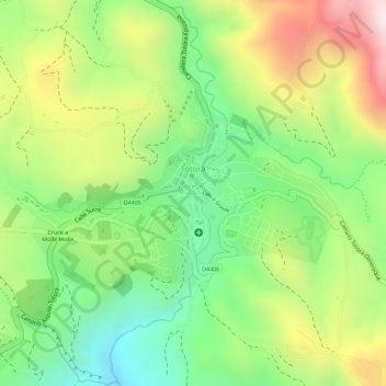
Nom : Carte topographique Totora, altitude, relief.
Lieu : Totora, Municipio Totora, Cochabamba, Bolivia (-17.74412 -65.20337 -17.73035 -65.18049)
Altitude moyenne : 2 870 m
Altitude minimum : 2 642 m
Altitude maximum : 3 154 m
Faire un don
Équipez-vous pour votre prochaine aventure :
En tant que Partenaire Amazon, ce site perçoit une commission sur les achats éligibles sans surcoût pour vous.