
Carte topographique Sopieszyno
Carte interactive
Cliquez sur la carte pour afficher l’altitude.
À propos de cette carte
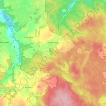
Nom : Carte topographique Sopieszyno, altitude, relief.
Altitude moyenne : 148 m
Altitude minimum : 63 m
Altitude maximum : 223 m
Autres cartes topographiques
Cliquez sur une carte pour visualiser sa topographie, son altitude et son relief.
Orle
Poland > Pomeranian Voivodeship > Wejherowo County
Orle, gmina Wejherowo, Wejherowo County, Pomeranian Voivodeship, Poland
Altitude moyenne : 43 m
Perlino-Wybudowa
Poland > Pomeranian Voivodeship > Wejherowo County > Perlino
Perlino-Wybudowa, Perlino, gmina Gniewino, Wejherowo County, Pomeranian Voivodeship, 84-250, Poland
Altitude moyenne : 58 m
Szemud
Poland > Pomeranian Voivodeship > Wejherowo County > Szemud
Szemud, gmina Szemud, Wejherowo County, Pomeranian Voivodeship, Poland
Altitude moyenne : 186 m
Przetoczyno
Poland > Pomeranian Voivodeship > Wejherowo County > Przetoczyno
Przetoczyno, gmina Szemud, Wejherowo County, Pomeranian Voivodeship, Poland
Altitude moyenne : 163 m
Rumia
Poland > Pomeranian Voivodeship > Wejherowo County > Rumia
Rumia, Wejherowo County, Pomeranian Voivodeship, 84-230, Poland
Altitude moyenne : 69 m
Reda
Poland > Pomeranian Voivodeship > Wejherowo County > Reda
Reda, Wejherowo County, Pomeranian Voivodeship, 84-240, Poland
Altitude moyenne : 46 m
Zbychowo
Poland > Pomeranian Voivodeship > Wejherowo County > Zbychowo
Zbychowo, gmina Wejherowo, Wejherowo County, Pomeranian Voivodeship, 84-206, Poland
Altitude moyenne : 148 m
Mierzyno
Poland > Pomeranian Voivodeship > Wejherowo County
Mierzyno, gmina Gniewino, Wejherowo County, Pomeranian Voivodeship, 84-250, Poland
Altitude moyenne : 70 m
Wejherowo
Poland > Pomeranian Voivodeship > Wejherowo County > Wejherowo
Wejherowo, Wejherowo County, Pomeranian Voivodeship, Poland
Altitude moyenne : 71 m