
Carte topographique Decatur
Carte interactive
Cliquez sur la carte pour afficher l’altitude.
Decatur
According to the United States Census Bureau, the city has a total area of 8.5 square miles (22 km2), all land. The highest point of elevation in the county is the courthouse site. As with ancient hill towns in Europe, the frontier settlement was developed on high ground for defensive purposes, so European settlers could see and ward off attacks or raids, in this case by Native Americans.
À propos de cette carte
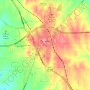
Nom : Carte topographique Decatur, altitude, relief.
Lieu : Decatur, Wise County, Texas, 76234, United States (33.19772 -97.62301 33.26524 -97.55589)
Altitude moyenne : 297 m
Altitude minimum : 245 m
Altitude maximum : 340 m