
Carte topographique Zinvié
Carte interactive
Cliquez sur la carte pour afficher l’altitude.
À propos de cette carte
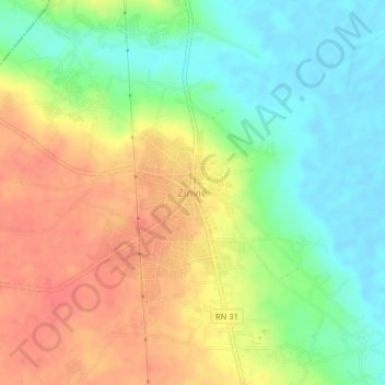
Nom : Carte topographique Zinvié, altitude, relief.
Lieu : Zinvié, Abomey-Calavi, Atlantique, Bénin (6.59338 2.33680 6.63338 2.37680)
Altitude moyenne : 28 m
Altitude minimum : -1 m
Altitude maximum : 58 m
Autres cartes topographiques
Cliquez sur une carte pour visualiser sa topographie, son altitude et son relief.
Akassato
Bénin > Atlantique > Abomey-Calavi
Akassato, Abomey-Calavi, Atlantique, Bénin
Altitude moyenne : 16 m
Godomey
Bénin > Atlantique > Abomey-Calavi
Godomey, Abomey-Calavi, Atlantique, Bénin
Altitude moyenne : 5 m
Sol pleureur
Bénin > Atlantique > Abomey-Calavi > Abomey-Calavi
Sol pleureur, RNIE 2, Awhanléko, Zoca, Abomey-Calavi, Atlantique, Bénin
Altitude moyenne : 25 m
Abomey-Calavi
Bénin > Atlantique > Abomey-Calavi
Abomey-Calavi, Atlantique, Bénin
Altitude moyenne : 13 m
Gbodjè
Bénin > Atlantique > Abomey-Calavi > Gbodjè
Gbodjè, Abomey-Calavi, Atlantique, Bénin
Altitude moyenne : 6 m
Djako Daho
Bénin > Atlantique > Abomey-Calavi > Djako Daho
Djako Daho, Abomey-Calavi, Atlantique, 299, Bénin
Altitude moyenne : 3 m