
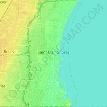
Carte topographique Saint Clair Shores
Carte interactive
Cliquez sur la carte pour afficher l’altitude.
À propos de cette carte
Nom : Carte topographique Saint Clair Shores, altitude, relief.
Lieu : Saint Clair Shores, Macomb County, Michigan, United States (42.45063 -82.92860 42.54092 -82.85514)
Altitude moyenne : 179 m
Altitude minimum : 171 m
Altitude maximum : 192 m
Autres cartes topographiques
Cliquez sur une carte pour visualiser sa topographie, son altitude et son relief.
Armada
United States > Michigan > Macomb County
Armada, Macomb County, Michigan, United States
Altitude moyenne : 228 m
Van Dyke
United States > Michigan > Macomb County > Warren
Van Dyke, Warren, Macomb County, Michigan, 48015, United States
Altitude moyenne : 192 m
Sterling Heights
United States > Michigan > Macomb County
Sterling Heights, Macomb County, Michigan, United States
Altitude moyenne : 191 m
Center Line
United States > Michigan > Macomb County
Center Line, Macomb County, Michigan, 48015, United States
Altitude moyenne : 192 m
Harrison Charter Township
United States > Michigan > Macomb County
Harrison Charter Township, Macomb County, Michigan, United States
Altitude moyenne : 177 m
Shelby Charter Township
United States > Michigan > Macomb County
Shelby Charter Township, Macomb County, Michigan, United States
Altitude moyenne : 205 m
Washington Charter Township
United States > Michigan > Macomb County
Washington Charter Township, Macomb County, Michigan, 48095, United States
Altitude moyenne : 240 m
Sterling Heights
United States > Michigan > Macomb County > Sterling Heights > Sterling Heights
Sterling Heights, Macomb County, Michigan, 48313-4615, United States
Altitude moyenne : 205 m
Macomb Township
United States > Michigan > Macomb County
Macomb Township, Macomb County, Michigan, United States
Altitude moyenne : 189 m
Shelby Charter Township
United States > Michigan > Macomb County > Shelby Charter Township
Shelby Charter Township, Macomb County, Michigan, 48094, United States
Altitude moyenne : 205 m