
Carte topographique Chadron
Carte interactive
Cliquez sur la carte pour afficher l’altitude.
À propos de cette carte
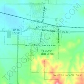
Nom : Carte topographique Chadron, altitude, relief.
Altitude moyenne : 1 052 m
Altitude minimum : 1 013 m
Altitude maximum : 1 181 m
Chadron is located at 3,400 feet in elevation. It is surrounded by prairie grassland, broken by a ridge of lightly forested hills to the south.