
Carte topographique Guardiagrele
Carte interactive
Cliquez sur la carte pour afficher l’altitude.
Guardiagrele
Guardiagrele (Italian pronunciation: [ɡuardiaˈɡreːle]; Abruzzese: La 'Uàrdije; Latin: Guardia Graelis) is a town and comune in the province of Chieti, part of the Abruzzo region of central Italy. It is in the foothills of the Maiella mountain at an elevation of around 576 metres (1,890 ft). Its population numbers about 10,000.
À propos de cette carte
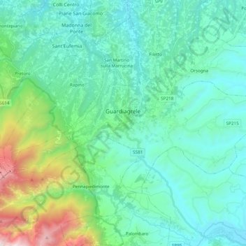
Nom : Carte topographique Guardiagrele, altitude, relief.
Lieu : Guardiagrele, Chieti, Abruzzo, 66016, Italy (42.14798 14.13535 42.22899 14.32673)
Altitude moyenne : 534 m
Altitude minimum : 126 m
Altitude maximum : 2 308 m
Autres cartes topographiques
Cliquez sur une carte pour visualiser sa topographie, son altitude et son relief.