
Carte topographique Sprucedale
Carte interactive
Cliquez sur la carte pour afficher l’altitude.
À propos de cette carte
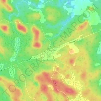
Nom : Carte topographique Sprucedale, altitude, relief.
Altitude moyenne : 330 m
Altitude minimum : 296 m
Altitude maximum : 363 m
Autres cartes topographiques
Cliquez sur une carte pour visualiser sa topographie, son altitude et son relief.
Buck Lake
Canada > Ontario > Parry Sound District > McMurrich/Monteith Township
Buck Lake, McMurrich/Monteith Township, District Municipality of Muskoka, Parry Sound District, Central Ontario, Ontario, Canada
Altitude moyenne : 325 m
Doe Lake
Canada > Ontario > Parry Sound District > McMurrich/Monteith Township
Doe Lake, McMurrich/Monteith Township, Parry Sound District, Central Ontario, Ontario, Canada
Altitude moyenne : 303 m
Axe Lake
Canada > Ontario > Parry Sound District > McMurrich/Monteith Township
Axe Lake, McMurrich/Monteith Township, Parry Sound District, Central Ontario, Ontario, Canada
Altitude moyenne : 330 m