
Carte topographique Horbling
Cliquez sur la carte pour afficher l’altitude.
À propos de cette carte
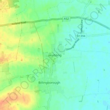
Nom : Carte topographique Horbling, altitude, relief.
Altitude moyenne : 12 m
Altitude minimum : 1 m
Altitude maximum : 34 m
Autres cartes topographiques
Cliquez sur une carte pour visualiser sa topographie, son altitude et son relief.
Carlton Scroop
United Kingdom > England > Lincolnshire > South Kesteven > Carlton Scroop
Altitude moyenne : 64 m
Witham on the Hill
United Kingdom > England > Lincolnshire > South Kesteven > Witham on the Hill
Altitude moyenne : 45 m
Uffington Park
United Kingdom > England > Lincolnshire > South Kesteven > Uffington
Altitude moyenne : 30 m
Deeping St. James
United Kingdom > England > Lincolnshire > South Kesteven > Frognall
Altitude moyenne : 5 m
Woolsthorpe By Belvoir
United Kingdom > England > Lincolnshire > South Kesteven > Woolsthorpe-by-Belvoir
Altitude moyenne : 74 m
Allington
United Kingdom > England > Lincolnshire > South Kesteven > Allington
Altitude moyenne : 37 m
Little Haw Wood
United Kingdom > England > Lincolnshire > South Kesteven > Castle Bytham
Altitude moyenne : 92 m
Witham on the Hill
United Kingdom > England > Lincolnshire > South Kesteven > Witham on the Hill
Altitude moyenne : 45 m