
Carte topographique Morasko
Carte interactive
Cliquez sur la carte pour afficher l’altitude.
À propos de cette carte
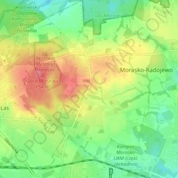
Nom : Carte topographique Morasko, altitude, relief.
Altitude moyenne : 108 m
Altitude minimum : 78 m
Altitude maximum : 146 m
West of Morasko village is the Morasko meteorite nature reserve, a forest area containing a group of depressions believed to be meteorite craters. Also within this reserve is Góra Moraska (Morasko Hill), whose summit is Poznań's highest point, with an altitude of 157 metres (515 ft). An avenue of trees along the road leading from the village to the reserve is designated as a natural monument.
Autres cartes topographiques
Cliquez sur une carte pour visualiser sa topographie, son altitude et son relief.
Szczepankowo-Spławie-Krzesinki
Poland > Greater Poland Voivodeship > Poznań
Szczepankowo-Spławie-Krzesinki, Poznan, Greater Poland Voivodeship, Poland
Altitude moyenne : 82 m
Starołęka Mała
Poland > Greater Poland Voivodeship > Poznań
Starołęka Mała, Starołęka-Minikowo-Marlewo, Poznań, Greater Poland Voivodeship, Poland
Altitude moyenne : 73 m