
Carte topographique St. Joseph Island
Carte interactive
Cliquez sur la carte pour afficher l’altitude.
St. Joseph Island
Its highest point, known colloquially and by surveyors as "the Mountain," is near the centre of the island near Carterton with an elevation of 345.6 m, which is about 169 m above Lake Huron.
À propos de cette carte
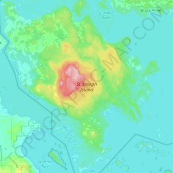
Nom : Carte topographique St. Joseph Island, altitude, relief.
Altitude moyenne : 196 m
Altitude minimum : 171 m
Altitude maximum : 348 m