
Carte topographique Phlio
Carte interactive
Cliquez sur la carte pour afficher l’altitude.
À propos de cette carte
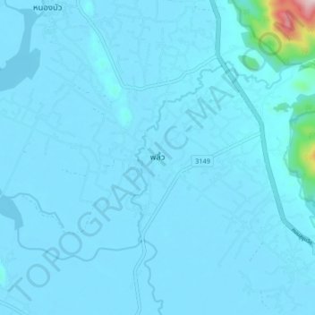
Nom : Carte topographique Phlio, altitude, relief.
Lieu : Phlio, Kwian Hak, Chanthaburi Province, Thailand (12.46434 102.10178 12.54434 102.18178)
Altitude moyenne : 18 m
Altitude minimum : -1 m
Altitude maximum : 455 m
Autres cartes topographiques
Cliquez sur une carte pour visualiser sa topographie, son altitude et son relief.
Bang Kacha
Thailand > Chanthaburi Province
Bang Kacha, Khai Noen Wong, Chanthaburi Province, 22120, Thailand
Altitude moyenne : 9 m
Na Yai Am
Thailand > Chanthaburi Province
Na Yai Am, Chang Kham, Chanthaburi Province, 22160, Thailand
Altitude moyenne : 13 m
Khlong Phlu
Thailand > Chanthaburi Province
Khlong Phlu, Chanthaburi Province, Thailand
Altitude moyenne : 238 m
Khao Baisi
Thailand > Chanthaburi Province
Khao Baisi, Chanthaburi Province, 22120, Thailand
Altitude moyenne : 19 m
Khao Wua–Phloi Waen
Thailand > Chanthaburi Province
Khao Wua–Phloi Waen, Chanthaburi Province, 22120, Thailand
Altitude moyenne : 37 m
Phlapphla
Thailand > Chanthaburi Province
Phlapphla, Chanthaburi Province, 22000, Thailand
Altitude moyenne : 59 m
Laem Sing
Thailand > Chanthaburi Province
Laem Sing, Ko Khwang, Chanthaburi Province, Thailand
Altitude moyenne : 2 m
Soi Dao
Thailand > Chanthaburi Province
Soi Dao, Chanthaburi Province, Thailand
Altitude moyenne : 274 m
Tha Chang
Thailand > Chanthaburi Province
Tha Chang, Salaeng, Chanthaburi Province, Thailand
Altitude moyenne : 16 m
Pluang Dam
Thailand > Chanthaburi Province
Pluang Dam, Wang Saem, Chanthaburi Province, Thailand
Altitude moyenne : 63 m
Chanthaburi
Thailand > Chanthaburi Province
Chanthaburi, Phlapphla Narai, Chanthaburi Province, 22000, Thailand
Altitude moyenne : 7 m
Sanam Chai
Thailand > Chanthaburi Province
Sanam Chai, Chanthaburi Province, Thailand
Altitude moyenne : 12 m