
Carte topographique Guntung Paikat
Carte interactive
Cliquez sur la carte pour afficher l’altitude.
À propos de cette carte
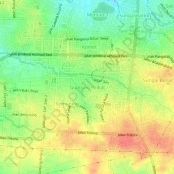
Nom : Carte topographique Guntung Paikat, altitude, relief.
Altitude moyenne : 34 m
Altitude minimum : 6 m
Altitude maximum : 60 m
Autres cartes topographiques
Cliquez sur une carte pour visualiser sa topographie, son altitude et son relief.
Loktabat Selatan
Indonésie > Kalimantan du Sud > Banjarbaru > Loktabat Selatan
Loktabat Selatan, Banjarbaru, Kalimantan du Sud, 70712, Indonésie
Altitude moyenne : 27 m