
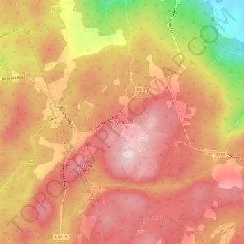
Carte topographique Foymount
Carte interactive
Cliquez sur la carte pour afficher l’altitude.
À propos de cette carte
Nom : Carte topographique Foymount, altitude, relief.
Altitude moyenne : 432 m
Altitude minimum : 248 m
Altitude maximum : 521 m
The location is also popular for amateur astronomers given the high altitude and low levels of artificial light.
Autres cartes topographiques
Cliquez sur une carte pour visualiser sa topographie, son altitude et son relief.
Eganville
Canada > Ontario > Renfrew County > Bonnechere Valley
Eganville, Bonnechere Valley, Renfrew County, Eastern Ontario, Ontario, K0J 1T0, Canada
Altitude moyenne : 186 m
Lake Clear
Canada > Ontario > Renfrew County > Bonnechere Valley
Lake Clear, Bonnechere Valley, Renfrew County, Eastern Ontario, Ontario, Canada
Altitude moyenne : 291 m
Roche Lake
Canada > Ontario > Renfrew County > Bonnechere Valley
Roche Lake, Bonnechere Valley, Renfrew County, Eastern Ontario, Ontario, Canada
Altitude moyenne : 257 m