
Carte topographique Vydrná
Carte interactive
Cliquez sur la carte pour afficher l’altitude.
À propos de cette carte
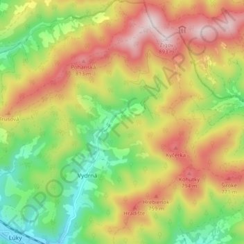
Nom : Carte topographique Vydrná, altitude, relief.
Altitude moyenne : 592 m
Altitude minimum : 336 m
Altitude maximum : 879 m
Autres cartes topographiques
Cliquez sur une carte pour visualiser sa topographie, son altitude et son relief.
Bezirk Puchau
Slowakei > Trentschiner Landschaftsverband > Bezirk Puchau
Bezirk Puchau, Trentschiner Landschaftsverband, Westslowakei, Slowakei
Altitude moyenne : 492 m