
Faire un don
Équipez-vous pour votre prochaine aventure :
En tant que Partenaire Amazon, ce site perçoit une commission sur les achats éligibles sans surcoût pour vous.
Carte topographique Scout Scar
Cliquez sur la carte pour afficher l’altitude.
Faire un don
Équipez-vous pour votre prochaine aventure :
En tant que Partenaire Amazon, ce site perçoit une commission sur les achats éligibles sans surcoût pour vous.
Scout Scar
Scout Scar, also called Underbarrow Scar, is a hill in the English Lake District, west of Kendal, Cumbria and above the village of Underbarrow. It reaches 771 feet (235 m). Scout Scar is the subject of a chapter of Wainwright's book The Outlying Fells of Lakeland, but the summit he describes is a lower summit at 764 feet (233 m), 270m south of the highest point. Wainwright's anticlockwise recommended route also includes Cunswick Scar at 679 feet (207 m). The higher summit of Scout Scar has a topographic prominence of 109m and is thus classified as a HuMP, a hill with a prominence of at least 100m.
Faire un don
Équipez-vous pour votre prochaine aventure :
En tant que Partenaire Amazon, ce site perçoit une commission sur les achats éligibles sans surcoût pour vous.
À propos de cette carte
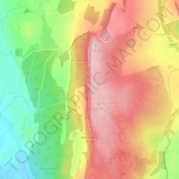
Nom : Carte topographique Scout Scar, altitude, relief.
Altitude moyenne : 130 m
Altitude minimum : 7 m
Altitude maximum : 233 m
Faire un don
Équipez-vous pour votre prochaine aventure :
En tant que Partenaire Amazon, ce site perçoit une commission sur les achats éligibles sans surcoût pour vous.