
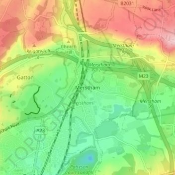
Carte topographique Merstham
Carte interactive
Cliquez sur la carte pour afficher l’altitude.
À propos de cette carte
Nom : Carte topographique Merstham, altitude, relief.
Altitude moyenne : 119 m
Altitude minimum : 46 m
Altitude maximum : 219 m
Autres cartes topographiques
Cliquez sur une carte pour visualiser sa topographie, son altitude et son relief.
Banstead
United Kingdom > England > Surrey > Reigate and Banstead
Banstead, Reigate and Banstead, Surrey, England, United Kingdom
Altitude moyenne : 142 m
Redhill
United Kingdom > England > Surrey > Reigate and Banstead
Redhill, Reigate and Banstead, Surrey, England, RH1 1RJ, United Kingdom
Altitude moyenne : 107 m
Horley
United Kingdom > England > Surrey > Reigate and Banstead
Horley, Reigate and Banstead, Surrey, England, United Kingdom
Altitude moyenne : 58 m