
Faire un don
Équipez-vous pour votre prochaine aventure :
En tant que Partenaire Amazon, ce site perçoit une commission sur les achats éligibles sans surcoût pour vous.
Carte topographique Ruthin
Cliquez sur la carte pour afficher l’altitude.
Faire un don
Équipez-vous pour votre prochaine aventure :
En tant que Partenaire Amazon, ce site perçoit une commission sur les achats éligibles sans surcoût pour vous.
Ruthin
The Myddleton Arms is also known as the Seven Eyes. It is said to have been built in the 14th century. The Dutch style design, long, steeped roof is attributed to Sir Richard Clough, an Elizabethan merchant. It has four tiers of dormer windows, each at a different elevation, known locally as the seven eyes of Ruthin. The property was acquired in 1595 by Sir Hugh Myddleton, who provided London with it first fresh water supply. The view of The Myddleton on the square is in fact of the rear of the building. The front looks out over the Clwydian Hills.
Faire un don
Équipez-vous pour votre prochaine aventure :
En tant que Partenaire Amazon, ce site perçoit une commission sur les achats éligibles sans surcoût pour vous.
À propos de cette carte
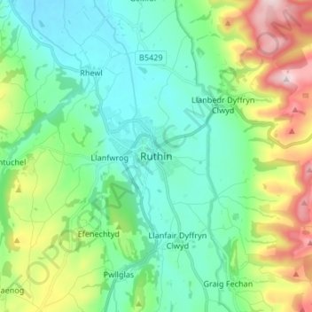
Nom : Carte topographique Ruthin, altitude, relief.
Lieu : Ruthin, Denbighshire, Wales, LL15 1BU, United Kingdom (53.07155 -3.34524 53.15155 -3.26524)
Altitude moyenne : 162 m
Altitude minimum : 35 m
Altitude maximum : 505 m
Faire un don
Équipez-vous pour votre prochaine aventure :
En tant que Partenaire Amazon, ce site perçoit une commission sur les achats éligibles sans surcoût pour vous.