
Carte topographique Seßlach
Carte interactive
Cliquez sur la carte pour afficher l’altitude.
À propos de cette carte
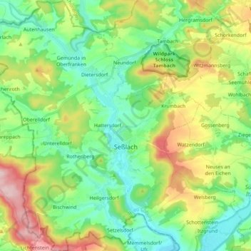
Nom : Carte topographique Seßlach, altitude, relief.
Lieu : Seßlach, Landkreis Coburg, Bayern, 96145, Deutschland (50.14120 10.72592 50.25180 10.89410)
Altitude moyenne : 325 m
Altitude minimum : 256 m
Altitude maximum : 463 m
Autres cartes topographiques
Cliquez sur une carte pour visualiser sa topographie, son altitude et son relief.
Heldritt
Deutschland > Bayern > Landkreis Coburg > Bad Rodach
Heldritt, Bad Rodach, Landkreis Coburg, Bayern, 96476, Deutschland
Altitude moyenne : 374 m
Sonnefeld
Deutschland > Bayern > Landkreis Coburg
Sonnefeld, Landkreis Coburg, Bayern, 96242, Deutschland
Altitude moyenne : 354 m
Ahlstadt
Deutschland > Bayern > Landkreis Coburg
Ahlstadt, Meeder, Landkreis Coburg, Bayern, Deutschland
Altitude moyenne : 435 m
Kleingarnstadt
Deutschland > Bayern > Landkreis Coburg
Kleingarnstadt, Ebersdorf b.Coburg, Landkreis Coburg, Bayern, Deutschland
Altitude moyenne : 385 m
Hattersdorf
Deutschland > Bayern > Landkreis Coburg > Seßlach
Hattersdorf, Seßlach, Landkreis Coburg, Bayern, 96145, Deutschland
Altitude moyenne : 300 m
Bad Rodach
Deutschland > Bayern > Landkreis Coburg
Bad Rodach, Landkreis Coburg, Bayern, 96476, Deutschland
Altitude moyenne : 352 m
Ahorn
Deutschland > Bayern > Landkreis Coburg
Ahorn, Landkreis Coburg, Bayern, 96482, Deutschland
Altitude moyenne : 333 m
Rödental
Deutschland > Bayern > Landkreis Coburg
Rödental, Landkreis Coburg, Bayern, 96472, Deutschland
Altitude moyenne : 381 m
Neustadt bei Coburg
Deutschland > Bayern > Landkreis Coburg
Neustadt bei Coburg, Landkreis Coburg, Bayern, 96465, Deutschland
Altitude moyenne : 372 m
Ebersdorf b.Coburg
Deutschland > Bayern > Landkreis Coburg
Ebersdorf b.Coburg, Landkreis Coburg, Bayern, 96237, Deutschland
Altitude moyenne : 351 m
Hassenberg
Deutschland > Bayern > Landkreis Coburg > Hassenberg
Hassenberg, Sonnefeld, Landkreis Coburg, Bayern, 96268, Deutschland
Altitude moyenne : 338 m
Scherneck
Deutschland > Bayern > Landkreis Coburg
Scherneck, Untersiemau, Landkreis Coburg, Bayern, 96253, Deutschland
Altitude moyenne : 307 m
Grub am Forst
Deutschland > Bayern > Landkreis Coburg > Grub a.Forst > Grub am Forst
Grub am Forst, Grub a.Forst, Grub am Forst (VGem), Landkreis Coburg, Bayern, 96271, Deutschland
Altitude moyenne : 343 m
Itzgrund
Deutschland > Bayern > Landkreis Coburg
Itzgrund, Landkreis Coburg, Bayern, 96274, Deutschland
Altitude moyenne : 307 m
Weitramsdorf
Deutschland > Bayern > Landkreis Coburg
Weitramsdorf, Landkreis Coburg, Bayern, 96479, Deutschland
Altitude moyenne : 341 m
Boderndorf
Deutschland > Bayern > Landkreis Coburg > Neustadt bei Coburg
Boderndorf, Neustadt bei Coburg, Landkreis Coburg, Bayern, 96465, Deutschland
Altitude moyenne : 369 m
Lahm
Deutschland > Bayern > Landkreis Coburg > Ebersdorf b.Coburg
Lahm, Ebersdorf b.Coburg, Landkreis Coburg, Bayern, 96271, Deutschland
Altitude moyenne : 361 m
Untersiemau
Deutschland > Bayern > Landkreis Coburg
Untersiemau, Landkreis Coburg, Bayern, 96253, Deutschland
Altitude moyenne : 319 m
Meeder
Deutschland > Bayern > Landkreis Coburg
Meeder, Landkreis Coburg, Bayern, 96484, Deutschland
Altitude moyenne : 398 m