
Carte topographique Bolinas
Carte interactive
Cliquez sur la carte pour afficher l’altitude.
Bolinas
Bolinas sits at an elevation of 36 feet (11 m) above sea level. It is bound on the northeast by Bolinas Lagoon and Kent Island and on the south by Bolinas Bay and Duxbury Point. According to the United States Census Bureau, the CDP has a total area of 5.8 square miles (15 km2), all of it land. The GNIS has cited archaic alternate town-names, including "Ballenas", "Baulenas", "Baulings", and "Bawlines".
À propos de cette carte
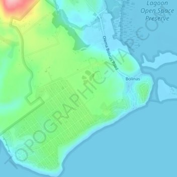
Nom : Carte topographique Bolinas, altitude, relief.
Altitude moyenne : 28 m
Altitude minimum : -1 m
Altitude maximum : 149 m