
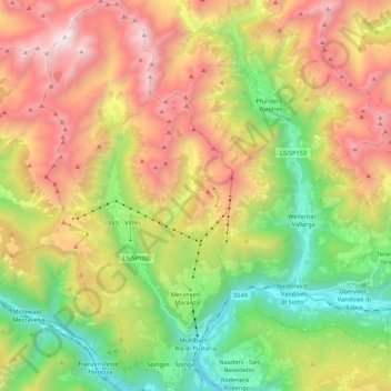
Carte topographique Mühlbach - Rio di Pusteria
Carte interactive
Cliquez sur la carte pour afficher l’altitude.
À propos de cette carte
Nom : Carte topographique Mühlbach - Rio di Pusteria, altitude, relief.
Altitude moyenne : 1 737 m
Altitude minimum : 665 m
Altitude maximum : 3 108 m
Autres cartes topographiques
Cliquez sur une carte pour visualiser sa topographie, son altitude et son relief.
Latsch - Laces
Italie > Trentin-Haut-Adige > Haut-Adige
Latsch - Laces, Vinschgau - Val Venosta, Haut-Adige, Trentin-Haut-Adige, 39021, Italie
Altitude moyenne : 1 618 m
Antholz Niedertal - Anterselva di Sotto
Italie > Trentin-Haut-Adige > Haut-Adige > Rasen-Antholz - Rasun-Anterselva
Antholz Niedertal - Anterselva di Sotto, Rasen-Antholz - Rasun-Anterselva, Pustertal - Val Pusteria, Haut-Adige, Trentin-Haut-Adige, 39030, Italie
Altitude moyenne : 1 537 m
Seiser Alm-Gruppe - Gruppo Mont de Sëuc - Gruppo dell'Alpe di Siusi
Italie > Trentin-Haut-Adige > Haut-Adige > Kastelruth - Castelrotto
Seiser Alm-Gruppe - Gruppo Mont de Sëuc - Gruppo dell'Alpe di Siusi, Kastelruth - Castelrotto, Salten-Schlern - Salto-Sciliar, Haut-Adige, Trentin-Haut-Adige, Italie
Altitude moyenne : 1 466 m
Urtijëi - St. Ulrich in Gröden - Ortisei
Italie > Trentin-Haut-Adige > Haut-Adige
Urtijëi - St. Ulrich in Gröden - Ortisei, Salten-Schlern - Salto-Sciliar, Haut-Adige, Trentin-Haut-Adige, 39046, Italie
Altitude moyenne : 1 688 m
Stilfs - Stelvio
Italie > Trentin-Haut-Adige > Haut-Adige
Stilfs - Stelvio, Vinschgau - Val Venosta, Haut-Adige, Trentin-Haut-Adige, 39029, Italie
Altitude moyenne : 2 419 m
Petersberg - Monte San Pietro
Italie > Trentin-Haut-Adige > Haut-Adige
Petersberg - Monte San Pietro, Deutschnofen - Nova Ponente, Salten-Schlern - Salto-Sciliar, Haut-Adige, Trentin-Haut-Adige, Italie
Altitude moyenne : 1 292 m
Kronplatz - Plan de Corones
Italie > Trentin-Haut-Adige > Haut-Adige > Bruneck - Brunico
Kronplatz - Plan de Corones, Bruneck - Brunico, Pustertal - Val Pusteria, Haut-Adige, Trentin-Haut-Adige, Italie
Altitude moyenne : 1 953 m
Schnals - Senales
Italie > Trentin-Haut-Adige > Haut-Adige
Schnals - Senales, Vinschgau - Val Venosta, Haut-Adige, Trentin-Haut-Adige, Italie
Altitude moyenne : 2 354 m
Speikboden
Italie > Trentin-Haut-Adige > Haut-Adige > Sand in Taufers - Campo Tures
Speikboden, Sand in Taufers - Campo Tures, Pustertal - Val Pusteria, Haut-Adige, Trentin-Haut-Adige, Italie
Altitude moyenne : 2 120 m
Gsies - Valle di Casies
Italie > Trentin-Haut-Adige > Haut-Adige
Gsies - Valle di Casies, Pustertal - Val Pusteria, Haut-Adige, Trentin-Haut-Adige, Italie
Altitude moyenne : 2 026 m
Mérano
Italie > Trentin-Haut-Adige > Haut-Adige > Mérano
Mérano, Burggrafenamt - Burgraviato, Haut-Adige, Trentin-Haut-Adige, 39012, Italie
Altitude moyenne : 635 m
Gerin
Italie > Trentin-Haut-Adige > Haut-Adige > Sarntal - Sarentino > Reinswald - San Martino
Gerin, Reinswald - San Martino, Sarntal - Sarentino, Salten-Schlern - Salto-Sciliar, Haut-Adige, Trentin-Haut-Adige, 39058, Italie
Altitude moyenne : 1 620 m
Sexten - Sesto
Italie > Trentin-Haut-Adige > Haut-Adige > Sexten - Sesto
Sexten - Sesto, Pustertal - Val Pusteria, Haut-Adige, Trentin-Haut-Adige, 39090, Italie
Altitude moyenne : 1 962 m
Brixen - Bressanone
Italie > Trentin-Haut-Adige > Haut-Adige > Brixen - Bressanone
Brixen - Bressanone, Eisacktal - Valle Isarco, Haut-Adige, Trentin-Haut-Adige, 39042, Italie
Altitude moyenne : 1 307 m