
Carte topographique Eramosa River
Carte interactive
Cliquez sur la carte pour afficher l’altitude.
À propos de cette carte
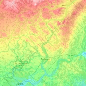
Nom : Carte topographique Eramosa River, altitude, relief.
Altitude moyenne : 384 m
Altitude minimum : 308 m
Altitude maximum : 491 m
Autres cartes topographiques
Cliquez sur une carte pour visualiser sa topographie, son altitude et son relief.
Guelph Lake
Canada > Ontario > Wellington County > Guelph/Eramosa > Eramosa
Guelph Lake, Eramosa, Guelph/Eramosa, Wellington County, Ontario, Canada
Altitude moyenne : 355 m
Rockwood
Canada > Ontario > Wellington County > Guelph/Eramosa
Rockwood, Guelph/Eramosa, Wellington County, Ontario, N0B 2K0, Canada
Altitude moyenne : 364 m
Eramosa
Canada > Ontario > Wellington County > Guelph/Eramosa > Eramosa
Eramosa, Guelph/Eramosa, Wellington County, Southwestern Ontario, Ontario, N1E 0G1, Canada
Altitude moyenne : 361 m