
Carte topographique Kudremukha
Carte interactive
Cliquez sur la carte pour afficher l’altitude.
À propos de cette carte
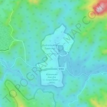
Nom : Carte topographique Kudremukha, altitude, relief.
Altitude moyenne : 858 m
Altitude minimum : 775 m
Altitude maximum : 1 239 m
The town of Kudremukha (KIOCL & etc.) lies at an elevation of around 815 metres (2,674 ft), whereas the peak stands at 1,894 metres (6,214 ft). The southern and western sides of the park form the steep slope of the Western Ghats ridgeline, with the altitude varying from 100 m - 1892 m (peak). The northern, central, and eastern portions of the park constitute a chain of rolling hills with a mosaic of natural grassland and shola forests. Kudremukha receives an average annual rainfall of 7000 mm, largely due to the forest types of mainly evergreen vegetation that can be found here.
Autres cartes topographiques
Cliquez sur une carte pour visualiser sa topographie, son altitude et son relief.
Kalasa
India > Karnataka > Kalasa taluk
Kalasa, Kalasa taluk, Chikkamagaluru District, Karnataka, 577124, India
Altitude moyenne : 897 m
Horanadu
India > Karnataka > Kalasa taluk
Horanadu, Kalasa taluk, Chikkamagaluru District, Karnataka, 577181, India
Altitude moyenne : 1 022 m