
Carte topographique Puzzle Lake Provincial Park
Carte interactive
Cliquez sur la carte pour afficher l’altitude.
À propos de cette carte
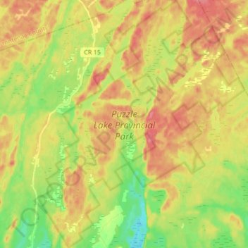
Nom : Carte topographique Puzzle Lake Provincial Park, altitude, relief.
Altitude moyenne : 196 m
Altitude minimum : 159 m
Altitude maximum : 229 m
Autres cartes topographiques
Cliquez sur une carte pour visualiser sa topographie, son altitude et son relief.
Newburgh
Canada > Ontario > Lennox and Addington County > Stone Mills
Newburgh, Stone Mills, Greater Napanee, Lennox and Addington County, Eastern Ontario, Ontario, K0K 2S0, Canada
Altitude moyenne : 129 m
Colebrook
Canada > Ontario > Lennox and Addington County > Stone Mills
Colebrook, Stone Mills, Lennox and Addington County, Eastern Ontario, Ontario, K0K 3N0, Canada
Altitude moyenne : 153 m
Erinsville
Canada > Ontario > Lennox and Addington County > Stone Mills
Erinsville, Stone Mills, Lennox and Addington County, Eastern Ontario, Ontario, K0K 2A0, Canada
Altitude moyenne : 174 m
Tamworth
Canada > Ontario > Lennox and Addington County > Stone Mills
Tamworth, Stone Mills, Lennox and Addington County, Eastern Ontario, Ontario, K0K 3G0, Canada
Altitude moyenne : 166 m
Moscow
Canada > Ontario > Lennox and Addington County > Stone Mills
Moscow, Stone Mills, Lennox and Addington County, Eastern Ontario, Ontario, Canada
Altitude moyenne : 146 m
Yarker
Canada > Ontario > Lennox and Addington County > Stone Mills
Yarker, Stone Mills, Lennox and Addington County, Eastern Ontario, Ontario, K0K 3N0, Canada
Altitude moyenne : 152 m