
Carte topographique Montebelluna
Carte interactive
Cliquez sur la carte pour afficher l’altitude.
À propos de cette carte
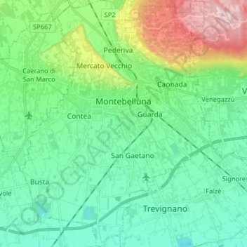
Nom : Carte topographique Montebelluna, altitude, relief.
Lieu : Montebelluna, Treviso, Veneto, 31044, Italy (45.72298 11.99231 45.81314 12.09770)
Altitude moyenne : 124 m
Altitude minimum : 40 m
Altitude maximum : 369 m
The territory of Montebelluna is largely flat, with altitudes ranging from 69 m a.s.l., found south of San Gaetano, to 144 m, north of Pederiva. The landscape is also characterized by the presence of two hills, including the western end of Montello (where the maximum altitude is, 343 m) and the more modest Capo di Monte (or Montebelluna Alta, or even the hill of Mercato Vecchio, 199 m). Between the two reliefs passes a natural corridor (along which the Feltrina passes), once the original bed of the Piave.
Autres cartes topographiques
Cliquez sur une carte pour visualiser sa topographie, son altitude et son relief.
Brioni
Italy > Veneto > Treviso > San Vito di Altivole
Brioni, San Vito di Altivole, Altivole, Fonte, Treviso, Veneto, 31039, Italy
Altitude moyenne : 83 m
Casale sul Sile
Casale sul Sile, Treviso, Veneto, 31032, Italy
Altitude moyenne : 6 m