
Carte topographique Rhinecliff
Carte interactive
Cliquez sur la carte pour afficher l’altitude.
À propos de cette carte
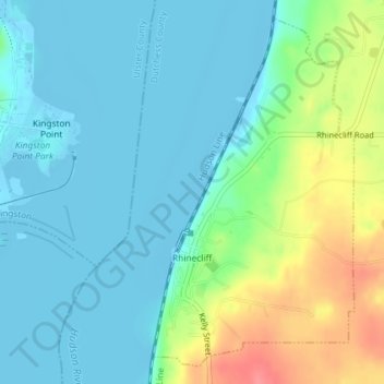
Nom : Carte topographique Rhinecliff, altitude, relief.
Altitude moyenne : 19 m
Altitude minimum : -9 m
Altitude maximum : 73 m
The hamlet is demarcated by large agricultural and wooded area to the north, east, and south, and bounded by the Hudson River on the west. Steep topography, formed by contorted slate ridges and valleys, define the site-specific and seemingly random orientation of the small, frame nineteenth-century houses and winding narrow roads. The hamlet had a mid-nineteenth century building boom, but its boundaries and building density have changed very little over the last one hundred years.