
Carte topographique Satara
Carte interactive
Cliquez sur la carte pour afficher l’altitude.
À propos de cette carte
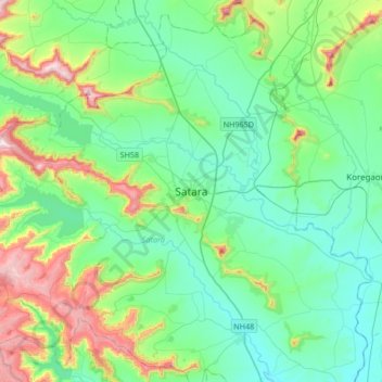
Nom : Carte topographique Satara, altitude, relief.
Lieu : Satara, Maharashtra, 415002, India (17.52832 73.84417 17.84832 74.16417)
Altitude moyenne : 748 m
Altitude minimum : 594 m
Altitude maximum : 1 250 m
Satara city has a tropical wet and dry climate (Köppen climate classification: Aw) that is influenced by the relatively high altitude and mountains surrounding the city. Summers are more hot than the winters. Satara city receives rainfall from 900 mm to 1,500 mm depending on the strength of the monsoon.
Autres cartes topographiques
Cliquez sur une carte pour visualiser sa topographie, son altitude et son relief.
Sajjangad
India > Maharashtra > Satara > New Banghar
Sajjangad, Thoseghar Road, New Banghar, Satara, Maharashtra, India
Altitude moyenne : 747 m
Ajinkyatara Fort
India > Maharashtra > Satara > Satara
Ajinkyatara Fort, Ajinkyatara Paschim Darawaja (West Gate) Road, Satara, Maharashtra, 415002, India
Altitude moyenne : 764 m
Urmodi River
India > Maharashtra > Satara > Satara
Urmodi River, Satara, Maharashtra, 415002, India
Altitude moyenne : 696 m