
Carte topographique Rietmolen
Carte interactive
Cliquez sur la carte pour afficher l’altitude.
À propos de cette carte
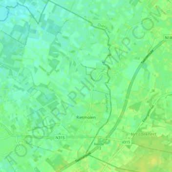
Nom : Carte topographique Rietmolen, altitude, relief.
Lieu : Rietmolen, Berkelland, Gelderland, Nederland (52.12488 6.60714 52.17419 6.67439)
Altitude moyenne : 20 m
Altitude minimum : 14 m
Altitude maximum : 28 m
Autres cartes topographiques
Cliquez sur une carte pour visualiser sa topographie, son altitude et son relief.
Gelselaar
Nederland > Gelderland > Berkelland
Gelselaar, Berkelland, Gelderland, Nederland
Altitude moyenne : 15 m
Kasteel Huize Ruurlo
Nederland > Gelderland > Berkelland
Kasteel Huize Ruurlo, Vordenseweg, Ruurlo, Berkelland, Gelderland, Nederland, 7261LM, Nederland
Altitude moyenne : 18 m