
Carte topographique Naseby
Carte interactive
Cliquez sur la carte pour afficher l’altitude.
À propos de cette carte
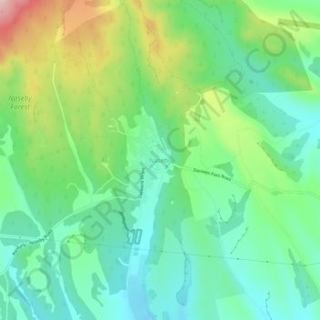
Nom : Carte topographique Naseby, altitude, relief.
Lieu : Naseby, Central Otago District, Otago, 9396, New Zealand (-45.04563 170.12782 -45.00563 170.16782)
Altitude moyenne : 617 m
Altitude minimum : 538 m
Altitude maximum : 786 m
Naseby is a small town, formerly a borough, in the Maniototo area of Central Otago, New Zealand. It is named after a village in Northamptonshire, England. Previous names of the township were Parker's, Hogburn and Mt Ida. The town catch phrase is "2000 feet above worry level" indicating its altitude. Naseby is 395 km (5 hours drive) from Christchurch and 143 km (1 hour 45 minutes drive) from Dunedin.
Autres cartes topographiques
Cliquez sur une carte pour visualiser sa topographie, son altitude et son relief.
Vincent Community
New Zealand > Otago > Central Otago District
Vincent Community, Central Otago District, Otago, New Zealand
Altitude moyenne : 776 m
Becks
New Zealand > Otago > Central Otago District > Vincent Community
Becks, Vincent Community, Central Otago District, Otago, 9377, New Zealand
Altitude moyenne : 393 m
Cromwell
New Zealand > Otago > Central Otago District > Cromwell Community > Cromwell
Cromwell, Cromwell Community, Central Otago District, Otago, 9310, New Zealand
Altitude moyenne : 330 m
Blue Lake
New Zealand > Otago > Central Otago District > Vincent Community > Saint Bathans
Blue Lake, Saint Bathans, Vincent Community, Central Otago District, Otago, New Zealand
Altitude moyenne : 605 m
Kakanui Peak
New Zealand > Otago > Central Otago District
Kakanui Peak, Central Otago District, Otago, New Zealand
Altitude moyenne : 1 169 m
Central Otago
New Zealand > Otago > Central Otago District > Vincent Community
Central Otago, Vincent Community, Central Otago District, Otago, 9035, New Zealand
Altitude moyenne : 935 m
Shingle Creek
New Zealand > Otago > Central Otago District > Teviot Valley Community
Shingle Creek, Teviot Valley Community, Central Otago District, Otago, New Zealand
Altitude moyenne : 307 m
Ranfurly
New Zealand > Otago > Central Otago District
Ranfurly, Central Otago District, Otago, 9332, New Zealand
Altitude moyenne : 429 m
Alexandra
New Zealand > Otago > Central Otago District > Vincent Community
Alexandra, Vincent Community, Central Otago District, Otago, 9320, New Zealand
Altitude moyenne : 241 m
Blackstone Hill
New Zealand > Otago > Central Otago District > Vincent Community
Blackstone Hill, Vincent Community, Central Otago District, Otago, 9377, New Zealand
Altitude moyenne : 789 m
Ophir
New Zealand > Otago > Central Otago District > Vincent Community
Ophir, Vincent Community, Central Otago District, Otago, 9376, New Zealand
Altitude moyenne : 338 m
Roxburgh
New Zealand > Otago > Central Otago District > Teviot Valley Community
Roxburgh, Teviot Valley Community, Central Otago District, Otago, 9500, New Zealand
Altitude moyenne : 223 m
Clyde
New Zealand > Otago > Central Otago District > Vincent Community
Clyde, Vincent Community, Central Otago District, Otago, 9330, New Zealand
Altitude moyenne : 316 m
Cromwell Community
New Zealand > Otago > Central Otago District
Cromwell Community, Central Otago District, Otago, New Zealand
Altitude moyenne : 876 m
Ida Valley
New Zealand > Otago > Central Otago District > Maniototo Community
Ida Valley, Maniototo Community, Central Otago District, Otago, New Zealand
Altitude moyenne : 472 m
Muttontown
New Zealand > Otago > Central Otago District > Vincent Community > Clyde
Muttontown, Clyde, Vincent Community, Central Otago District, Otago, 9391, New Zealand
Altitude moyenne : 207 m
Millers Flat
New Zealand > Otago > Central Otago District > Teviot Valley Community
Millers Flat, Teviot Valley Community, Central Otago District, Otago, 9572, New Zealand
Altitude moyenne : 161 m
Wedderburn
New Zealand > Otago > Central Otago District
Wedderburn, Central Otago District, Otago, 9395, New Zealand
Altitude moyenne : 565 m