
Carte topographique Howick
Carte interactive
Cliquez sur la carte pour afficher l’altitude.
À propos de cette carte
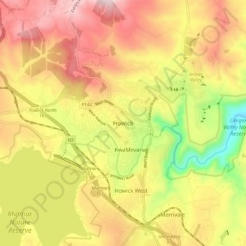
Nom : Carte topographique Howick, altitude, relief.
Altitude moyenne : 1 066 m
Altitude minimum : 780 m
Altitude maximum : 1 304 m
Howick is possibly the location of the first crewed flight in the world. Evidence exists that a John Goodman Household flew a self made glider in 1871 and again in 1875 on the outskirts of Howick, close to Karkloof. The actual distance flown and altitude achieved differs from source to source (some sources say the distance was 80 metres (260 feet)) but what can be verified is that the distance flown was further, and the duration also longer, than either of the flights made by Lilienthal or the Wright brothers. Today there exists a memorial to Household's achievement at Curry's Post, also a small distance outside Howick.