
Carte topographique La Spezia
Carte interactive
Cliquez sur la carte pour afficher l’altitude.
À propos de cette carte
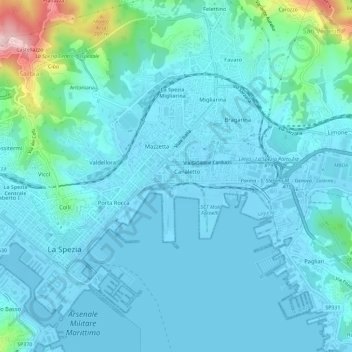
Nom : Carte topographique La Spezia, altitude, relief.
Lieu : La Spezia, Follo, La Spezia, Liguria, Italy (44.09906 9.79646 44.12501 9.85458)
Altitude moyenne : 35 m
Altitude minimum : -3 m
Altitude maximum : 274 m
Because of its topography, the city is not exposed to winds from the north, which lap western Liguria, but to those from the southeast. These may bring heavy rain and they can reach 80 kilometres per hour (50 mph), in rare cases causing the blocking of the port. The only northern wind reaching the city is the north-eastern Grecale, common during incursions of Arctic air, when the cold air flowing over the warmer Tyrrhenian sea triggers the formation of low pressures, draining the colder and heavier air trapped in the Po Valley, behind the Apennine Mountains.
Autres cartes topographiques
Cliquez sur une carte pour visualiser sa topographie, son altitude et son relief.
Cinque Terre
Italy > Liguria > La Spezia > Vernazza
Cinque Terre, Vernazza, Follo, La Spezia, Liguria, 19010, Italy
Altitude moyenne : 221 m
Riomaggiore
Riomaggiore, La Spezia, Liguria, 19017, Italy
Altitude moyenne : 250 m