
Carte topographique El Cordon
Carte interactive
Cliquez sur la carte pour afficher l’altitude.
À propos de cette carte
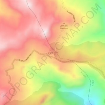
Nom : Carte topographique El Cordon, altitude, relief.
Altitude moyenne : 3 521 m
Altitude minimum : 3 118 m
Altitude maximum : 3 794 m
Autres cartes topographiques
Cliquez sur une carte pour visualiser sa topographie, son altitude et son relief.
Río Arzobispo
Colombia > Boyacá > Socotá > Los Pinos
Río Arzobispo, Los Pinos, Socotá, Valderrama, Boyacá, RAP (Especial) Central, Colombia
Altitude moyenne : 3 467 m