
Faire un don
Équipez-vous pour votre prochaine aventure :
En tant que Partenaire Amazon, ce site perçoit une commission sur les achats éligibles sans surcoût pour vous.
Carte topographique Posthudorra/Porto Torres
Cliquez sur la carte pour afficher l’altitude.
Faire un don
Équipez-vous pour votre prochaine aventure :
En tant que Partenaire Amazon, ce site perçoit une commission sur les achats éligibles sans surcoût pour vous.
Posthudorra/Porto Torres
The morphology of "city part" is flat; the area of Porto Torres and the rest of north-west Sardinia is characterized by a Nurra plain, with some hill formations in the middle of it. Part of this hill formation is in the municipality of Porto Torres, the highest elevation being Monte Alvaro, rising to a height of 342 m above sea level.
Faire un don
Équipez-vous pour votre prochaine aventure :
En tant que Partenaire Amazon, ce site perçoit une commission sur les achats éligibles sans surcoût pour vous.
À propos de cette carte
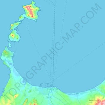
Nom : Carte topographique Posthudorra/Porto Torres, altitude, relief.
Lieu : Posthudorra/Porto Torres, Sassari, Sardinia, 07046, Italy (40.78142 8.20876 41.12073 8.45885)
Altitude moyenne : 15 m
Altitude minimum : -1 m
Altitude maximum : 418 m
Faire un don
Équipez-vous pour votre prochaine aventure :
En tant que Partenaire Amazon, ce site perçoit une commission sur les achats éligibles sans surcoût pour vous.
Autres cartes topographiques
Cliquez sur une carte pour visualiser sa topographie, son altitude et son relief.