
Carte topographique District de Maseru
Carte interactive
Cliquez sur la carte pour afficher l’altitude.
À propos de cette carte
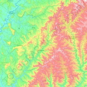
Nom : Carte topographique District de Maseru, altitude, relief.
Lieu : District de Maseru, Lesotho (-29.92525 27.29985 -29.27551 28.25039)
Altitude moyenne : 2 030 m
Altitude minimum : 1 461 m
Altitude maximum : 3 091 m
Autres cartes topographiques
Cliquez sur une carte pour visualiser sa topographie, son altitude et son relief.
Maletsunyane Falls
Lesotho > District de Maseru > Thusong Ha Moahloli
Maletsunyane Falls, Thusong Ha Moahloli, District de Maseru, Lesotho
Altitude moyenne : 2 201 m
Maletsunyane River
Maletsunyane River, District de Maseru, Lesotho
Altitude moyenne : 2 397 m
Thabana Ntlenyana
Lesotho > District de Mokhotlong
Thabana Ntlenyana, District de Mokhotlong, Lesotho
Altitude moyenne : 3 313 m
Mokhotlong
Lesotho > Mokhotlong District > Mokhotlong
Mokhotlong, Mokhotlong District, Lesotho
Altitude moyenne : 2 293 m
Mokhotlong
Mokhotlong, Mokhotlong District, Lesotho
Altitude moyenne : 2 899 m
Mafeteng
Lesotho > Mafeteng District > Mafeteng
Mafeteng, Mafeteng District, Lesotho
Altitude moyenne : 1 673 m
Drakensberg
Lesotho > District de Mokhotlong
Drakensberg, District de Mokhotlong, Lesotho
Altitude moyenne : 3 286 m