
Carte topographique Dutse
Carte interactive
Cliquez sur la carte pour afficher l’altitude.
À propos de cette carte
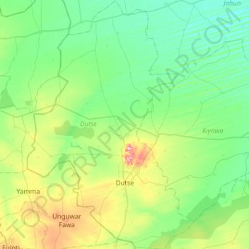
Nom : Carte topographique Dutse, altitude, relief.
Lieu : Dutse, Jigawa State, 720231, Nigeria (11.55712 9.13891 12.05689 9.48096)
Altitude moyenne : 411 m
Altitude minimum : 373 m
Altitude maximum : 546 m
With an estimated population of 153,000 (2009), Dutse is currently the largest city in Jigawa State followed by Hadejia (111,000), Gumel (43,000), and Birnin Kudu (27,000). Dutse is the capital of Jigawa state of Nigeria. The state was created in 1991 during the military regime of General Ibrahim Badamasi Babangida. Dutse (Dutsi, in earlier notes) got its name from the rocky topography peculiar to the area. Different forms of rocks can be seen widely spread across the town. Mostly igneous in nature, the rocky town got its name from this naturally endowed resources, Dutse (Hausa term for rock). Dutse and its environ are well known for Date Trees (Dabino) of different variety. The area is characterised with undulating topography and hilly walls. The name Jigawa (from Jigayi) is attributed to such topology. Peculiar to the North-Western states, the population of Dutse are predominantly Hausa and Fulani. With availability of agrarian land, the inhabitants of Dutse are predominantly farmers; other occupations typical to rural area are also available among the populace.
Autres cartes topographiques
Cliquez sur une carte pour visualiser sa topographie, son altitude et son relief.
Zandam Nagogo
Nigeria > Jigawa State > Gwaram
Zandam Nagogo, Gwaram, Jigawa State, Nigeria
Altitude moyenne : 437 m
Turbus
Nigeria > Jigawa State > Maigatari
Turbus, Maigatari, Jigawa State, Nigeria
Altitude moyenne : 359 m