
Carte topographique Arambagh
Cliquez sur la carte pour afficher l’altitude.
Arambagh
Arambagh is located at 22°53′N 87°47′E / 22.88°N 87.78°E / 22.88; 87.78. It has an average elevation of 15 metres (118 feet). The town is situated on the link Road (state highway-2) 81Km north-west of Kolkata, 27 Km north-west of Tarakeswar, 39 Km south-east of Bardhaman. It is located on the bank of the Dwarakeswar River.
À propos de cette carte
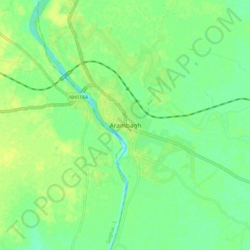
Nom : Carte topographique Arambagh, altitude, relief.
Altitude moyenne : 17 m
Altitude minimum : 8 m
Altitude maximum : 25 m
Autres cartes topographiques
Cliquez sur une carte pour visualiser sa topographie, son altitude et son relief.