
Faire un don
Équipez-vous pour votre prochaine aventure :
En tant que Partenaire Amazon, ce site perçoit une commission sur les achats éligibles sans surcoût pour vous.
Carte topographique Burgtonna
Cliquez sur la carte pour afficher l’altitude.
Faire un don
Équipez-vous pour votre prochaine aventure :
En tant que Partenaire Amazon, ce site perçoit une commission sur les achats éligibles sans surcoût pour vous.
À propos de cette carte
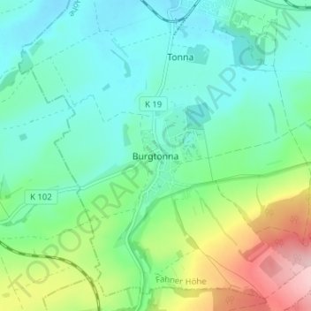
Nom : Carte topographique Burgtonna, altitude, relief.
Altitude moyenne : 234 m
Altitude minimum : 178 m
Altitude maximum : 388 m
Faire un don
Équipez-vous pour votre prochaine aventure :
En tant que Partenaire Amazon, ce site perçoit une commission sur les achats éligibles sans surcoût pour vous.
Autres cartes topographiques
Cliquez sur une carte pour visualiser sa topographie, son altitude et son relief.
Gotha
Germany > Thuringia > Landkreis Gotha
Gotha is situated in a flat landscape within the fertile Thuringian Basin. A tectonic dislocation traverses the city from north-west to south-east. Thereby, it forms three prominent hills: the 431 m high Krahnberg with the Ratsholz forest in the north-west, the hill of Friedenstein Castle in the city centre…
Altitude moyenne : 320 m
Faire un don
Équipez-vous pour votre prochaine aventure :
En tant que Partenaire Amazon, ce site perçoit une commission sur les achats éligibles sans surcoût pour vous.