
Faire un don
Équipez-vous pour votre prochaine aventure :
En tant que Partenaire Amazon, ce site perçoit une commission sur les achats éligibles sans surcoût pour vous.
Carte topographique Natrona Heights
Cliquez sur la carte pour afficher l’altitude.
Faire un don
Équipez-vous pour votre prochaine aventure :
En tant que Partenaire Amazon, ce site perçoit une commission sur les achats éligibles sans surcoût pour vous.
À propos de cette carte
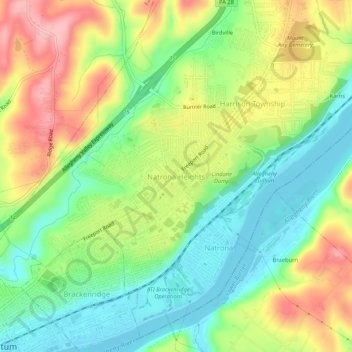
Nom : Carte topographique Natrona Heights, altitude, relief.
Altitude moyenne : 289 m
Altitude minimum : 226 m
Altitude maximum : 376 m
Faire un don
Équipez-vous pour votre prochaine aventure :
En tant que Partenaire Amazon, ce site perçoit une commission sur les achats éligibles sans surcoût pour vous.
Autres cartes topographiques
Cliquez sur une carte pour visualiser sa topographie, son altitude et son relief.
Pittsburgh
United States > Pennsylvania > Allegheny County
Pittsburgh, located in Allegheny County, Pennsylvania, is characterized by its distinct and varied topography, shaped by the confluence of the Allegheny, Monongahela, and Ohio rivers. The city itself is situated at an average elevation of approximately 764 feet (233 meters) above sea level, with the terrain…
Altitude moyenne : 303 m
California-Kirkbride
United States > Pennsylvania > Allegheny County > Pittsburgh
Altitude moyenne : 256 m
Faire un don
Équipez-vous pour votre prochaine aventure :
En tant que Partenaire Amazon, ce site perçoit une commission sur les achats éligibles sans surcoût pour vous.
Brighton Heights
United States > Pennsylvania > Allegheny County > Pittsburgh
Altitude moyenne : 281 m
Pittsburgh
United States > Pennsylvania > Allegheny County
The warmest month of the year in Pittsburgh is July, with a 24-hour average of 73.2 °F (22.9 °C). Conditions are often humid, and combined with highs reaching 90 °F (32 °C) on an average 9.5 days a year, a considerable heat index arises. The coolest month is January, when the 24-hour average is 28.8 °F…
Altitude moyenne : 303 m
Faire un don
Équipez-vous pour votre prochaine aventure :
En tant que Partenaire Amazon, ce site perçoit une commission sur les achats éligibles sans surcoût pour vous.
Bethel Park
United States > Pennsylvania > Allegheny County
According to the U.S. Census Bureau, the borough had a total area of 11.7 square miles (30 km2), all land. Its average elevation is 1,197 feet (365 m) above sea level. Bethel Park lies at the margin between the Pittsburgh Low Plateau and Waynesburg Hills Sections of the Allegheny Plateau physiographic…
Altitude moyenne : 347 m
Pittsburgh
United States > Pennsylvania > Allegheny County
The warmest month of the year in Pittsburgh is July, with a 24-hour average of 73.2 °F (22.9 °C). Conditions are often humid, and combined with highs reaching 90 °F (32 °C) on an average 9.5 days a year, a considerable heat index arises. The coolest month is January, when the 24-hour average is 28.8 °F…
Altitude moyenne : 303 m
Faire un don
Équipez-vous pour votre prochaine aventure :
En tant que Partenaire Amazon, ce site perçoit une commission sur les achats éligibles sans surcoût pour vous.
Bridgeville
United States > Pennsylvania > Allegheny County
Even more significant to the development of Bridgeville was the advent of commercial coal mining. The Pittsburgh Coal Seam was perhaps the most valuable mineral resource in North America in the late 1800s. Ranging from forty inches to six feet thick it was located at an elevation that produced outcroppings on…
Altitude moyenne : 275 m
Faire un don
Équipez-vous pour votre prochaine aventure :
En tant que Partenaire Amazon, ce site perçoit une commission sur les achats éligibles sans surcoût pour vous.
Moon Township
United States > Pennsylvania > Allegheny County
During the Cold War, Moon Township was the location of Nike Site PI-71, which was a battery of Nike Ajax and/or Nike Hercules surface-to-air missiles, used by US armed forces for high – and medium-altitude air defense. The former missile site is now a nature preserve.
Altitude moyenne : 316 m
Faire un don
Équipez-vous pour votre prochaine aventure :
En tant que Partenaire Amazon, ce site perçoit une commission sur les achats éligibles sans surcoût pour vous.
Faire un don
Équipez-vous pour votre prochaine aventure :
En tant que Partenaire Amazon, ce site perçoit une commission sur les achats éligibles sans surcoût pour vous.
Central Northside
United States > Pennsylvania > Allegheny County > Pittsburgh
Altitude moyenne : 264 m
Neville Island
United States > Pennsylvania > Allegheny County > Neville Township
Altitude moyenne : 289 m
Faire un don
Équipez-vous pour votre prochaine aventure :
En tant que Partenaire Amazon, ce site perçoit une commission sur les achats éligibles sans surcoût pour vous.
Spring Hill-City View
United States > Pennsylvania > Allegheny County > Pittsburgh
Altitude moyenne : 292 m
Point Breeze North
United States > Pennsylvania > Allegheny County > Pittsburgh
Altitude moyenne : 296 m
Reserve Township
United States > Pennsylvania > Allegheny County
The land that became Reserve Township was part of a 3,000-acre (1,200 ha) tract that the Pennsylvania General Assembly reserved in 1783 for state use, from which the township later took its name. Surveyed by Alexander McClean in 1785, the tract extended at least one mile inland from the Allegheny and Ohio…
Altitude moyenne : 312 m
Carnegie
United States > Pennsylvania > Allegheny County
According to the United States Census Bureau, the borough has a total area of 1.6 square miles (4.1 km2), all land. Its average elevation is 833 ft (254 m) above sea level.
Altitude moyenne : 275 m
Faire un don
Équipez-vous pour votre prochaine aventure :
En tant que Partenaire Amazon, ce site perçoit une commission sur les achats éligibles sans surcoût pour vous.
Braddock
United States > Pennsylvania > Allegheny County
According to the U.S. Census Bureau, the borough has a total area of 0.6 square miles (1.6 km2), 0.6 square miles (1.6 km2) of which is land and 0.1 square miles (0.26 km2) (13.85%) of which is water. Its average elevation is 764 ft (233 m) above sea level.
Altitude moyenne : 275 m
Faire un don
Équipez-vous pour votre prochaine aventure :
En tant que Partenaire Amazon, ce site perçoit une commission sur les achats éligibles sans surcoût pour vous.
Braddock Hills
United States > Pennsylvania > Allegheny County
According to the United States Census Bureau, the borough has a total area of 1.0 square mile (2.6 km2), all land. Its average elevation is 1,102 ft (336 m) above sea level.
Altitude moyenne : 322 m
Faire un don
Équipez-vous pour votre prochaine aventure :
En tant que Partenaire Amazon, ce site perçoit une commission sur les achats éligibles sans surcoût pour vous.
Faire un don
Équipez-vous pour votre prochaine aventure :
En tant que Partenaire Amazon, ce site perçoit une commission sur les achats éligibles sans surcoût pour vous.
Allegheny River Lock and Dam No. 2
United States > Pennsylvania > Allegheny County > O'Hara Township
Altitude moyenne : 268 m
Carnegie
United States > Pennsylvania > Allegheny County
According to the United States Census Bureau, the borough has a total area of 1.6 square miles (4.1 km2), all land. Its average elevation is 833 ft (254 m) above sea level.
Altitude moyenne : 275 m
Highland Park Reservoir No. 2
United States > Pennsylvania > Allegheny County > Pittsburgh
Altitude moyenne : 275 m
Faire un don
Équipez-vous pour votre prochaine aventure :
En tant que Partenaire Amazon, ce site perçoit une commission sur les achats éligibles sans surcoût pour vous.
Moon Township
United States > Pennsylvania > Allegheny County
During the Cold War, Moon Township was the location of Nike Site PI-71, which was a battery of Nike Ajax and/or Nike Hercules surface-to-air missiles, used by US armed forces for high – and medium-altitude air defense. The former missile site is now a nature preserve.
Altitude moyenne : 316 m
Faire un don
Équipez-vous pour votre prochaine aventure :
En tant que Partenaire Amazon, ce site perçoit une commission sur les achats éligibles sans surcoût pour vous.
Faire un don
Équipez-vous pour votre prochaine aventure :
En tant que Partenaire Amazon, ce site perçoit une commission sur les achats éligibles sans surcoût pour vous.
Bethel Park
United States > Pennsylvania > Allegheny County
According to the U.S. Census Bureau, the borough had a total area of 11.7 square miles (30 km2), all of it land. Its average elevation is 1,197 feet (365 m) above sea level. Bethel Park lies at the margin between the Pittsburgh Low Plateau and Waynesburg Hills Sections of the Allegheny Plateau physiographic…
Altitude moyenne : 347 m
Faire un don
Équipez-vous pour votre prochaine aventure :
En tant que Partenaire Amazon, ce site perçoit une commission sur les achats éligibles sans surcoût pour vous.
South Park Township
United States > Pennsylvania > Allegheny County
The township is on the Allegheny Plateau, near where the Allegheny River from the northeast and Monongahela River from the southeast join to form the Ohio River in Pittsburgh. South Park township's topography is quite hilly. The hilltops are somewhat "carved" out by the streams in the area.
Altitude moyenne : 332 m
Faire un don
Équipez-vous pour votre prochaine aventure :
En tant que Partenaire Amazon, ce site perçoit une commission sur les achats éligibles sans surcoût pour vous.
Castle Shannon
United States > Pennsylvania > Allegheny County
According to the United States Census Bureau, the borough has a total area of 1.6 square miles (4.1 km2), all land. Its average elevation is 1,040 feet (320 m) above sea level.
Altitude moyenne : 354 m
South Fayette Township
United States > Pennsylvania > Allegheny County
According to the United States Census Bureau, the township has a total area of 20.4 square miles (53 km2), of which 20.95 square miles (54.3 km2) is land and 0.05% is water. The topography is mostly wooded with small hills and floodplains on four streams. It is located 14 miles (23 km) southwest of Pittsburgh.
Altitude moyenne : 328 m
Faire un don
Équipez-vous pour votre prochaine aventure :
En tant que Partenaire Amazon, ce site perçoit une commission sur les achats éligibles sans surcoût pour vous.
Aleppo Township
United States > Pennsylvania > Allegheny County
According to the United States Census Bureau, the township has a total area of 1.8 square miles (4.7 km2), all land. Its average elevation is 1,112 feet (339 m) above sea level.
Altitude moyenne : 303 m
Faire un don
Équipez-vous pour votre prochaine aventure :
En tant que Partenaire Amazon, ce site perçoit une commission sur les achats éligibles sans surcoût pour vous.
Faire un don
Équipez-vous pour votre prochaine aventure :
En tant que Partenaire Amazon, ce site perçoit une commission sur les achats éligibles sans surcoût pour vous.
Faire un don
Équipez-vous pour votre prochaine aventure :
En tant que Partenaire Amazon, ce site perçoit une commission sur les achats éligibles sans surcoût pour vous.
Pittsburgh
United States > Pennsylvania > Allegheny County
The warmest month of the year in Pittsburgh is July, with a 24-hour average of 73.2 °F (22.9 °C). Conditions are often humid, and combined with highs reaching 90 °F (32 °C) on an average 9.5 days a year, a considerable heat index arises. The coolest month is January, when the 24-hour average is 28.8 °F…
Altitude moyenne : 303 m
Faire un don
Équipez-vous pour votre prochaine aventure :
En tant que Partenaire Amazon, ce site perçoit une commission sur les achats éligibles sans surcoût pour vous.
Russellton
United States > Pennsylvania > Allegheny County > West Deer Township
Altitude moyenne : 325 m
Faire un don
Équipez-vous pour votre prochaine aventure :
En tant que Partenaire Amazon, ce site perçoit une commission sur les achats éligibles sans surcoût pour vous.
Carnegie
United States > Pennsylvania > Allegheny County
According to the United States Census Bureau, the borough has a total area of 1.6 square miles (4.1 km2), all land. Its average elevation is 833 ft (254 m) above sea level.
Altitude moyenne : 275 m
Faire un don
Équipez-vous pour votre prochaine aventure :
En tant que Partenaire Amazon, ce site perçoit une commission sur les achats éligibles sans surcoût pour vous.
Pittsburgh
United States > Pennsylvania > Allegheny County
The warmest month of the year in Pittsburgh is July, with a 24-hour average of 73.2 °F (22.9 °C). Conditions are often humid, and combined with highs reaching 90 °F (32 °C) on an average 9.5 days a year, a considerable heat index arises. The coolest month is January, when the 24-hour average is 28.8 °F…
Altitude moyenne : 303 m
Faire un don
Équipez-vous pour votre prochaine aventure :
En tant que Partenaire Amazon, ce site perçoit une commission sur les achats éligibles sans surcoût pour vous.