
Carte topographique La Pépinière
Carte interactive
Cliquez sur la carte pour afficher l’altitude.
À propos de cette carte
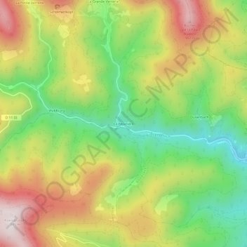
Nom : Carte topographique La Pépinière, altitude, relief.
Altitude moyenne : 584 m
Altitude minimum : 281 m
Altitude maximum : 936 m
Autres cartes topographiques
Cliquez sur une carte pour visualiser sa topographie, son altitude et son relief.
Taennchel
France > Grand Est > Haut-Rhin > Ribeauvillé
Taennchel, Ribeauvillé, Colmar-Ribeauvillé, Haut-Rhin, Grand Est, France métropolitaine, 68150, France
Altitude moyenne : 740 m
Schelmenkopf
France > Grand Est > Haut-Rhin > Ribeauvillé
Schelmenkopf, Ribeauvillé, Colmar-Ribeauvillé, Haut-Rhin, Grand Est, France métropolitaine, 68150, France
Altitude moyenne : 681 m
Dusenbach
France > Grand Est > Haut-Rhin > Ribeauvillé
Dusenbach, Ribeauvillé, Colmar-Ribeauvillé, Haut-Rhin, Grand Est, France métropolitaine, 68150, France
Altitude moyenne : 507 m
Chalet du Club Vosgiens Ribeauvillé
France > Grand Est > Haut-Rhin > Ribeauvillé > Schelmenkopf
Chalet du Club Vosgiens Ribeauvillé, Chemin du Schelmenkopf, Schelmenkopf, Ribeauvillé, Colmar-Ribeauvillé, Haut-Rhin, Grand Est, France métropolitaine, 68150, France
Altitude moyenne : 700 m