
Carte topographique Fairfield County
Carte interactive
Cliquez sur la carte pour afficher l’altitude.
À propos de cette carte
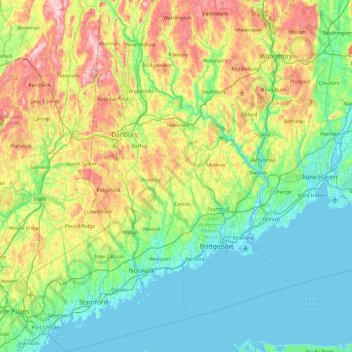
Nom : Carte topographique Fairfield County, altitude, relief.
Lieu : Fairfield County, Connecticut, United States (40.95098 -73.72778 41.66672 -73.06505)
Altitude moyenne : 115 m
Altitude minimum : -5 m
Altitude maximum : 408 m
The terrain of the county trends from flat near the coast to hilly and higher near its northern extremity. The highest elevation is 1,290 feet (393 m) above sea level along the New York state line south of Branch Hill in the Town of Sherman; the lowest point is sea level itself.
Autres cartes topographiques
Cliquez sur une carte pour visualiser sa topographie, son altitude et son relief.
Wilton
United States > Connecticut > Fairfield County
Wilton, Fairfield County, Connecticut, 06897, United States
Altitude moyenne : 118 m
Sunnyside
United States > Connecticut > Fairfield County > Shelton
Sunnyside, Shelton, Fairfield County, Connecticut, 06418, United States
Altitude moyenne : 54 m
Pinneys Corners
United States > Connecticut > Fairfield County > New Canaan
Pinneys Corners, New Canaan, Fairfield County, Connecticut, 06840, United States
Altitude moyenne : 143 m
Shelton
United States > Connecticut > Fairfield County > Shelton
Shelton, Fairfield County, Connecticut, United States
Altitude moyenne : 86 m