
Faire un don
Équipez-vous pour votre prochaine aventure :
En tant que Partenaire Amazon, ce site perçoit une commission sur les achats éligibles sans surcoût pour vous.
Carte topographique Busto Arsizio
Cliquez sur la carte pour afficher l’altitude.
Faire un don
Équipez-vous pour votre prochaine aventure :
En tant que Partenaire Amazon, ce site perçoit une commission sur les achats éligibles sans surcoût pour vous.
Busto Arsizio
It was the road that connected Busto Arsizio to Arnate (today a district of Gallarate), corresponding to today's Via Gioacchino Rossini and its continuation of Via Gaetano Donizetti, which leads into Piazza Alessandro Manzoni, together with Via Quintino Sella, at the church of the Madonna in Prato. The name Garlasca is already found in 1399 in the Libro della Decima (Book of the Tithe) and also appears again in the Cadastre of 1857. In the topography of the late 19th century, it is found with the name of Galarasca local road, while from the beginning of the 20th century the current names of Via Gaetano Donizetti, for the first short stretch near the town centre, and Via Gioaccino Rossini appear.
Faire un don
Équipez-vous pour votre prochaine aventure :
En tant que Partenaire Amazon, ce site perçoit une commission sur les achats éligibles sans surcoût pour vous.
À propos de cette carte
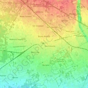
Nom : Carte topographique Busto Arsizio, altitude, relief.
Lieu : Busto Arsizio, Varese, Lombardy, 21052, Italy (45.56813 8.80479 45.64263 8.88197)
Altitude moyenne : 220 m
Altitude minimum : 190 m
Altitude maximum : 251 m
Faire un don
Équipez-vous pour votre prochaine aventure :
En tant que Partenaire Amazon, ce site perçoit une commission sur les achats éligibles sans surcoût pour vous.
Autres cartes topographiques
Cliquez sur une carte pour visualiser sa topographie, son altitude et son relief.
Pianca
Italy > Lombardy > Varese > Maccagno con Pino e Veddasca > Maccagno Superiore
Altitude moyenne : 364 m
Parco archeologico di Castel Seprio
Italy > Lombardy > Varese > Castelseprio > Vico Seprio
Altitude moyenne : 314 m
Faire un don
Équipez-vous pour votre prochaine aventure :
En tant que Partenaire Amazon, ce site perçoit une commission sur les achats éligibles sans surcoût pour vous.