
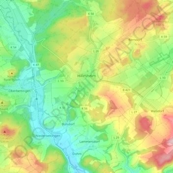
Carte topographique Hillesheim
Carte interactive
Cliquez sur la carte pour afficher l’altitude.
À propos de cette carte
Nom : Carte topographique Hillesheim, altitude, relief.
Altitude moyenne : 461 m
Altitude minimum : 377 m
Altitude maximum : 588 m
Autres cartes topographiques
Cliquez sur une carte pour visualiser sa topographie, son altitude et son relief.
Stadtkyll
Deutschland > Rheinland-Pfalz > Landkreis Vulkaneifel
Stadtkyll, Gerolstein, Landkreis Vulkaneifel, Rheinland-Pfalz, 54589, Deutschland
Altitude moyenne : 541 m
Bongard
Deutschland > Rheinland-Pfalz > Landkreis Vulkaneifel
Bongard, Kelberg, Landkreis Vulkaneifel, Rheinland-Pfalz, Deutschland
Altitude moyenne : 525 m
Kerpen (Eifel)
Deutschland > Rheinland-Pfalz > Landkreis Vulkaneifel
Kerpen (Eifel), Gerolstein, Landkreis Vulkaneifel, Rheinland-Pfalz, Deutschland
Altitude moyenne : 481 m
Mannebach
Deutschland > Rheinland-Pfalz > Landkreis Vulkaneifel
Mannebach, Kelberg, Landkreis Vulkaneifel, Rheinland-Pfalz, Deutschland
Altitude moyenne : 520 m