
Carte topographique Cholmondeston
Carte interactive
Cliquez sur la carte pour afficher l’altitude.
À propos de cette carte
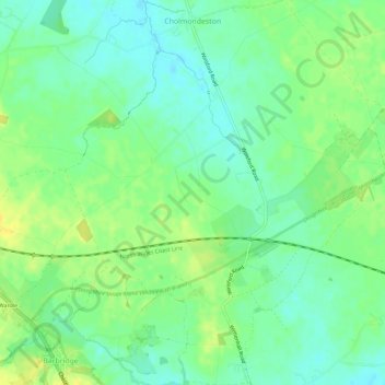
Nom : Carte topographique Cholmondeston, altitude, relief.
Lieu : Cholmondeston, Cheshire East, England, United Kingdom (53.10299 -2.57477 53.13714 -2.52158)
Altitude moyenne : 48 m
Altitude minimum : 38 m
Altitude maximum : 60 m
The civil parish has a total area of 1,749 acres (708 ha).[17] The terrain is predominantly flat, with an average elevation of around 50 metres. A trig point is located at SJ631567, at an elevation of 55 metres. Crowton Brook runs north–south through the civil parish and Bankside Brook forms part of the northern boundary; there are numerous scattered small meres and ponds. Several small areas of woodland are located within the civil parish. The small village of Cholmondeston (SJ628599) lies in the north of the civil parish at the junction between Winsford Road, Minshull Lane and Calveley Green Lane.[18] The area is predominantly rural, with the major land use being agricultural.[19]
Autres cartes topographiques
Cliquez sur une carte pour visualiser sa topographie, son altitude et son relief.
Nether Alderley
United Kingdom > England > Cheshire East
Nether Alderley, Cheshire East, England, United Kingdom
Altitude moyenne : 98 m
Smallwood
United Kingdom > England > Cheshire East
Smallwood, Cheshire East, England, United Kingdom
Altitude moyenne : 86 m
Wilmslow
United Kingdom > England > Cheshire East
Wilmslow, Cheshire East, England, United Kingdom
Altitude moyenne : 81 m
Norbury
United Kingdom > England > Cheshire East
Norbury, Cheshire East, England, United Kingdom
Altitude moyenne : 82 m
Bickerton Hill
United Kingdom > England > Cheshire East > Bickerton
Bickerton Hill, Bickerton, Cheshire East, England, CH3 9LE, United Kingdom
Altitude moyenne : 134 m
Wilmslow
United Kingdom > England > Cheshire East
Wilmslow, Cheshire East, England, SK9 1DS, United Kingdom
Altitude moyenne : 84 m
Knutsford
United Kingdom > England > Cheshire East
Knutsford, Cheshire East, England, United Kingdom
Altitude moyenne : 58 m
Alderley Edge
United Kingdom > England > Cheshire East > Alderley Edge
Alderley Edge, Cheshire East, North West England, England, United Kingdom
Altitude moyenne : 91 m
Middlewich
United Kingdom > England > Cheshire East
Middlewich, Cheshire East, England, United Kingdom
Altitude moyenne : 40 m
Ashley
United Kingdom > England > Cheshire East
Ashley, Cheshire East, England, WA15 0QR, United Kingdom
Altitude moyenne : 44 m
Nantwich
United Kingdom > England > Cheshire East
Nantwich, Cheshire East, England, United Kingdom
Altitude moyenne : 45 m
Church Minshull
United Kingdom > England > Cheshire East
Church Minshull, Cheshire East, England, United Kingdom
Altitude moyenne : 45 m
Smith's Green
United Kingdom > England > Cheshire East > Barthomley > Smith's Green
Smith's Green, Barthomley, Cheshire East, North West England, England, CW2 5NU, United Kingdom
Altitude moyenne : 80 m
Disley
United Kingdom > England > Cheshire East
Disley, Cheshire East, North West England, England, United Kingdom
Altitude moyenne : 229 m
Chorley
United Kingdom > England > Cheshire East > Chorley
Chorley, Cheshire East, North West England, England, United Kingdom
Altitude moyenne : 73 m
Walgherton
United Kingdom > England > Cheshire East > Wybunbury > Walgherton
Walgherton, Wybunbury, Cheshire East, North West England, England, United Kingdom
Altitude moyenne : 63 m
Macclesfield
United Kingdom > England > Cheshire East
Macclesfield, Cheshire East, England, United Kingdom
Altitude moyenne : 182 m
Congleton
United Kingdom > England > Cheshire East
Congleton, Cheshire East, England, United Kingdom
Altitude moyenne : 119 m
Crewe
United Kingdom > England > Cheshire East
Crewe, Cheshire East, England, United Kingdom
Altitude moyenne : 52 m
Doddington
United Kingdom > England > Cheshire East
Doddington, Cheshire East, England, United Kingdom
Altitude moyenne : 73 m