
Faire un don
Équipez-vous pour votre prochaine aventure :
En tant que Partenaire Amazon, ce site perçoit une commission sur les achats éligibles sans surcoût pour vous.
Carte topographique Ulten - Ultimo
Cliquez sur la carte pour afficher l’altitude.
Faire un don
Équipez-vous pour votre prochaine aventure :
En tant que Partenaire Amazon, ce site perçoit une commission sur les achats éligibles sans surcoût pour vous.
Ulten - Ultimo
Le premier village de la municipalité d'Ulten, le hameau principal de St. Walburg (Santa Valpurga), est à environ 17,5 km au sud-ouest de Meran (Merano) et à environ 7,5 km de St. Pankraz (San Pancrazio) à une altitude de 1 190 m. Le hameau de Kuppelwies (1 153 m) suit dans la vallée, puis viennent les hameaux de St. Nikolaus (San Nicolò) (1 256 m) et St. Gertraud (Santa Gertrude) (1 501 m). Ulten comprend aussi de nombreuses fermes dispersées.
Faire un don
Équipez-vous pour votre prochaine aventure :
En tant que Partenaire Amazon, ce site perçoit une commission sur les achats éligibles sans surcoût pour vous.
À propos de cette carte
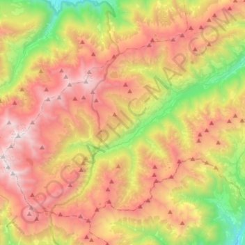
Nom : Carte topographique Ulten - Ultimo, altitude, relief.
Altitude moyenne : 2 003 m
Altitude minimum : 662 m
Altitude maximum : 3 417 m
Faire un don
Équipez-vous pour votre prochaine aventure :
En tant que Partenaire Amazon, ce site perçoit une commission sur les achats éligibles sans surcoût pour vous.
Autres cartes topographiques
Cliquez sur une carte pour visualiser sa topographie, son altitude et son relief.
Freina
Italie > Trentin-Haut-Adige > Haut-Adige > San Martin de Tor - San Martino in Badia - St. Martin in Thurn > Lungiarü - Campill - Longiarù
Altitude moyenne : 1 698 m
Faire un don
Équipez-vous pour votre prochaine aventure :
En tant que Partenaire Amazon, ce site perçoit une commission sur les achats éligibles sans surcoût pour vous.
Hochgall - Monte Collalto
Italie > Trentin-Haut-Adige > Haut-Adige > Rasen-Antholz - Rasun-Anterselva
Altitude moyenne : 2 807 m
Sulden - Solda
Italie > Trentin-Haut-Adige > Haut-Adige > Stilfs - Stelvio
Sulden se trouve au pied de l'Ortles, dans le Vinschgau, vallée de l'est du col du Stelvio. Il est situé à 1 900 m d'altitude, et sa population est d'environ 400 habitants.
Altitude moyenne : 2 232 m
Weitental - Vallarga
Italie > Trentin-Haut-Adige > Haut-Adige > Vintl - Vandoies
Altitude moyenne : 1 306 m
Faire un don
Équipez-vous pour votre prochaine aventure :
En tant que Partenaire Amazon, ce site perçoit une commission sur les achats éligibles sans surcoût pour vous.
Klobenstein - Collalbo
Italie > Trentin-Haut-Adige > Haut-Adige > Ritten - Renon
Altitude moyenne : 1 135 m
Pescosta
Italie > Trentin-Haut-Adige > Haut-Adige > Corvara in Badia - Corvara
Altitude moyenne : 1 827 m
St. Felix - San Felice
Italie > Trentin-Haut-Adige > Haut-Adige > Unsere Liebe Frau im Walde-St. Felix - Senale-San Felice
Altitude moyenne : 1 354 m
Faire un don
Équipez-vous pour votre prochaine aventure :
En tant que Partenaire Amazon, ce site perçoit une commission sur les achats éligibles sans surcoût pour vous.
Piz Sella
Italie > Trentin-Haut-Adige > Haut-Adige > Sëlva - Wolkenstein - Selva di Val Gardena
Altitude moyenne : 2 106 m
Flains - Flaines
Italie > Trentin-Haut-Adige > Haut-Adige > Pfitsch - Val di Vizze > Wiesen - Prati
Altitude moyenne : 1 116 m
St. Valentin - San Valentino
Italie > Trentin-Haut-Adige > Haut-Adige > St. Peter - San Pietro
Altitude moyenne : 1 321 m
Faire un don
Équipez-vous pour votre prochaine aventure :
En tant que Partenaire Amazon, ce site perçoit une commission sur les achats éligibles sans surcoût pour vous.
Astfeld - Campolasta
Italie > Trentin-Haut-Adige > Haut-Adige > Sarntal - Sarentino
Altitude moyenne : 1 356 m
Oberkor - Quaira di sopra
Italie > Trentin-Haut-Adige > Haut-Adige > Deutschnofen - Nova Ponente
Altitude moyenne : 1 307 m
Plosescharte - Forcella Plose
Italie > Trentin-Haut-Adige > Haut-Adige > Brixen - Bressanone > Kreuztal - Val Croce
Altitude moyenne : 2 027 m
Faire un don
Équipez-vous pour votre prochaine aventure :
En tant que Partenaire Amazon, ce site perçoit une commission sur les achats éligibles sans surcoût pour vous.
Kronplatz - Plan de Corones
Italie > Trentin-Haut-Adige > Haut-Adige > Bruneck - Brunico
Altitude moyenne : 1 953 m
Eastern Alps
Italie > Trentin-Haut-Adige > Haut-Adige > Ahrntal - Valle Aurina
Altitude moyenne : 1 431 m
Hirschegg - Punta del Cervo
Italie > Trentin-Haut-Adige > Haut-Adige > Sarntal - Sarentino
Altitude moyenne : 2 158 m
Faire un don
Équipez-vous pour votre prochaine aventure :
En tant que Partenaire Amazon, ce site perçoit une commission sur les achats éligibles sans surcoût pour vous.
Luttach - Lutago
Italie > Trentin-Haut-Adige > Haut-Adige > Ahrntal - Valle Aurina
Altitude moyenne : 1 372 m
Turnerkamp - Cima di Campo
Italie > Trentin-Haut-Adige > Haut-Adige > Mühlwald - Selva dei Molini
Le Turnerkamp, ou Cima di Campo en italien, est une montagne qui s’élève à 3 416 ou 3 420 m d’altitude dans les Alpes de Zillertal, à la frontière entre l'Autriche et l'Italie.
Altitude moyenne : 2 868 m
Faire un don
Équipez-vous pour votre prochaine aventure :
En tant que Partenaire Amazon, ce site perçoit une commission sur les achats éligibles sans surcoût pour vous.
Monte Nevoso - Schneebiger Nock
Italie > Trentin-Haut-Adige > Haut-Adige > Sand in Taufers - Campo Tures
Le Schneebiger Nock ou Monte Nevoso est un sommet de la province autonome de Bolzano en Italie. Il culmine à 3 358 mètres d'altitude.
Altitude moyenne : 2 817 m
Ortler - Ortles
Italie > Trentin-Haut-Adige > Haut-Adige > Stilfs - Stelvio
Tous les itinéraires vers le sommet sont des circuits de haute altitude exigeants. Il est recouvert sur la face nord-ouest par un glacier. La face nord de la montagne est considérée comme la plus grande paroi de glace des Alpes orientales, bien que de plus en plus de roches émergent à cause de la fonte…
Altitude moyenne : 3 175 m
Antholzer Tal - Valle di Anterselva
Italie > Trentin-Haut-Adige > Haut-Adige > Rasen-Antholz - Rasun-Anterselva
Altitude moyenne : 1 867 m
Faire un don
Équipez-vous pour votre prochaine aventure :
En tant que Partenaire Amazon, ce site perçoit une commission sur les achats éligibles sans surcoût pour vous.
St. Kathrein - Santa Caterina
Italie > Trentin-Haut-Adige > Haut-Adige > Hafling Oberdorf - Avelengo di Sopra
Altitude moyenne : 999 m
St. Vigil - San Vigilio
Italie > Trentin-Haut-Adige > Haut-Adige > Kastelruth - Castelrotto
Altitude moyenne : 1 033 m
Faire un don
Équipez-vous pour votre prochaine aventure :
En tant que Partenaire Amazon, ce site perçoit une commission sur les achats éligibles sans surcoût pour vous.
Flimkanzel - Pulpito di Flim
Italie > Trentin-Haut-Adige > Haut-Adige > Ulten - Ultimo
Altitude moyenne : 2 710 m
Elzenbaum - Pruno
Italie > Trentin-Haut-Adige > Haut-Adige > Freienfeld - Campo di Trens
Altitude moyenne : 1 230 m
Faire un don
Équipez-vous pour votre prochaine aventure :
En tant que Partenaire Amazon, ce site perçoit une commission sur les achats éligibles sans surcoût pour vous.
Sorá
Italie > Trentin-Haut-Adige > Haut-Adige > Calfosch - Kolfuschg - Colfosco
Altitude moyenne : 1 891 m
Großer Löffler - Monte Lovello
Italie > Trentin-Haut-Adige > Haut-Adige > Ahrntal - Valle Aurina
Altitude moyenne : 2 727 m
Faire un don
Équipez-vous pour votre prochaine aventure :
En tant que Partenaire Amazon, ce site perçoit une commission sur les achats éligibles sans surcoût pour vous.
Rötspitz
Italie > Trentin-Haut-Adige > Haut-Adige > Prettau - Predoi
La Rötspitze (ou en italien : Pizzo Rosso) est une montagne qui s’élève à 3 495 ou 3 496 m d’altitude dans les Hohe Tauern, à la frontière entre l'Autriche et l'Italie.
Altitude moyenne : 2 877 m
Königspitze - Gran Zebrù
Italie > Trentin-Haut-Adige > Haut-Adige > Stilfs - Stelvio
Son profil prononcé domine deux vallées de haute altitude : le val Zebrù du côté valtellinais, vallée latérale de la basse Valfurva, et la valle di Solda (Suldental) du côté tyrolien, vallée latérale du val Venosta.
Altitude moyenne : 3 139 m
Flemberg - Monte Flemm
Italie > Trentin-Haut-Adige > Haut-Adige > Mühlwald - Selva dei Molini
Altitude moyenne : 2 286 m
Schmieden - Ferrara
Italie > Trentin-Haut-Adige > Haut-Adige > Prags - Braies
Altitude moyenne : 1 426 m
Faire un don
Équipez-vous pour votre prochaine aventure :
En tant que Partenaire Amazon, ce site perçoit une commission sur les achats éligibles sans surcoût pour vous.
Lengmoos - Longomoso
Italie > Trentin-Haut-Adige > Haut-Adige > Ritten - Renon > Klobenstein - Collalbo
Altitude moyenne : 1 049 m
Reschen - Resia
Italie > Trentin-Haut-Adige > Haut-Adige > Graun - Curon Venosta
Altitude moyenne : 1 814 m
Faire un don
Équipez-vous pour votre prochaine aventure :
En tant que Partenaire Amazon, ce site perçoit une commission sur les achats éligibles sans surcoût pour vous.
Gadertal - Val Badia
Italie > Trentin-Haut-Adige > Haut-Adige > Corvara in Badia - Corvara
Altitude moyenne : 1 988 m
Runcadic - Runggaditsch - Roncadizza
Italie > Trentin-Haut-Adige > Haut-Adige > Kastelruth - Castelrotto
Altitude moyenne : 1 520 m
Gherdëina - Grödnertal - Val Gardena
Italie > Trentin-Haut-Adige > Haut-Adige > Urtijëi - St. Ulrich in Gröden - Ortisei
Dans le val Gardena se trouvent de nombreux lacs, généralement au-dessus de 2 000 m d'altitude : le lech dl Dragon (2 680 m), le lac Crespëina (2 380 m), les lacs lech Sant (2 096 m), le lech d'Iman (2 208 m), le lech da Rijeda 2 135 m) ou encore le lech dla Scaies (2 050 m) sur l'alpage de Mastlè.
Altitude moyenne : 1 588 m
Faire un don
Équipez-vous pour votre prochaine aventure :
En tant que Partenaire Amazon, ce site perçoit une commission sur les achats éligibles sans surcoût pour vous.
Pens - Pennes
Italie > Trentin-Haut-Adige > Haut-Adige > Sarntal - Sarentino
Altitude moyenne : 1 850 m
Secёda - Monte Seceda
Italie > Trentin-Haut-Adige > Haut-Adige > Santa Cristina Gherdëina - St. Christina in Gröden - Santa Cristina Valgardena
Altitude moyenne : 2 106 m
Pinei
Italie > Trentin-Haut-Adige > Haut-Adige > Marèo - Enneberg - Marebbe > Al Plan de Mareo - St. Vigil in Enneberg - San Vigilio di Marebbe
Altitude moyenne : 1 419 m
Saslonch - Langkofel - Sassolungo
Italie > Trentin-Haut-Adige > Haut-Adige > Sëlva - Wolkenstein - Selva di Val Gardena
Altitude moyenne : 2 320 m
Faire un don
Équipez-vous pour votre prochaine aventure :
En tant que Partenaire Amazon, ce site perçoit une commission sur les achats éligibles sans surcoût pour vous.
Etsch - Adige
Italie > Trentin-Haut-Adige > Haut-Adige > Tarnell - Tarnello > Oberplatz
Altitude moyenne : 1 075 m
Compatsch
Italie > Trentin-Haut-Adige > Haut-Adige > Kastelruth - Castelrotto
Altitude moyenne : 1 859 m
Faire un don
Équipez-vous pour votre prochaine aventure :
En tant que Partenaire Amazon, ce site perçoit une commission sur les achats éligibles sans surcoût pour vous.
Kreuztal - Val Croce
Italie > Trentin-Haut-Adige > Haut-Adige > Brixen - Bressanone
Altitude moyenne : 1 704 m
Faire un don
Équipez-vous pour votre prochaine aventure :
En tant que Partenaire Amazon, ce site perçoit une commission sur les achats éligibles sans surcoût pour vous.
Stilfserbrücke - Ponte Stelvio
Italie > Trentin-Haut-Adige > Haut-Adige > Stilfs - Stelvio
Altitude moyenne : 1 582 m
Antermëia - Untermoi - Antermoia
Italie > Trentin-Haut-Adige > Haut-Adige > San Martin de Tor - San Martino in Badia - St. Martin in Thurn
Altitude moyenne : 1 677 m
Milland - Millan
Italie > Trentin-Haut-Adige > Haut-Adige > Brixen - Bressanone > Milland - Millan
Altitude moyenne : 769 m
Faire un don
Équipez-vous pour votre prochaine aventure :
En tant que Partenaire Amazon, ce site perçoit une commission sur les achats éligibles sans surcoût pour vous.
Vilpian - Vilpiano
Italie > Trentin-Haut-Adige > Haut-Adige > Terlan - Terlano > Vilpian - Vilpiano
Altitude moyenne : 457 m
Unser Frau - Madonna
Italie > Trentin-Haut-Adige > Haut-Adige > Schnals - Senales
Altitude moyenne : 1 977 m
St. Veit - S. Vito
Italie > Trentin-Haut-Adige > Haut-Adige > Kardaun - Cardano
Altitude moyenne : 735 m
Brennerbad - Terme di Brennero
Italie > Trentin-Haut-Adige > Haut-Adige > Brenner - Brennero
Altitude moyenne : 1 761 m
Faire un don
Équipez-vous pour votre prochaine aventure :
En tant que Partenaire Amazon, ce site perçoit une commission sur les achats éligibles sans surcoût pour vous.
Durnholz - Valdurna
Italie > Trentin-Haut-Adige > Haut-Adige > Sarntal - Sarentino
Altitude moyenne : 1 901 m
Unsere Liebe Frau im Walde - Senale
Italie > Trentin-Haut-Adige > Haut-Adige > Unsere Liebe Frau im Walde-St. Felix - Senale-San Felice
Altitude moyenne : 1 590 m
Reischach - Riscone
Italie > Trentin-Haut-Adige > Haut-Adige > Bruneck - Brunico
Altitude moyenne : 1 022 m
Urtijëi - St. Ulrich - Ortisei
Italie > Trentin-Haut-Adige > Haut-Adige > Urtijëi - St. Ulrich in Gröden - Ortisei > Urtijëi - St. Ulrich - Ortisei
Altitude moyenne : 1 548 m
Faire un don
Équipez-vous pour votre prochaine aventure :
En tant que Partenaire Amazon, ce site perçoit une commission sur les achats éligibles sans surcoût pour vous.
Villa Nöia
Italie > Trentin-Haut-Adige > Haut-Adige > La Ila - Stern - La Villa
Altitude moyenne : 1 632 m
Pragser Wildsee - Lago di Braies
Italie > Trentin-Haut-Adige > Haut-Adige > Prags - Braies
Altitude moyenne : 1 744 m