
Carte topographique Leiderdorp
Carte interactive
Cliquez sur la carte pour afficher l’altitude.
À propos de cette carte
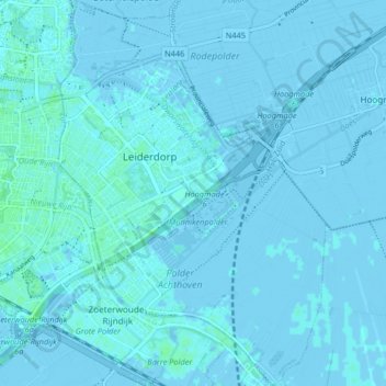
Nom : Carte topographique Leiderdorp, altitude, relief.
Lieu : Leiderdorp, Zuid-Holland, Nederland (52.13190 4.51469 52.18212 4.57148)
Altitude moyenne : 0 m
Altitude minimum : -4 m
Altitude maximum : 5 m
Autres cartes topographiques
Cliquez sur une carte pour visualiser sa topographie, son altitude et son relief.
Polder Achthoven
Nederland > Zuid-Holland > Leiderdorp
Polder Achthoven, 't Heerlijk Recht, Leiderdorp, Zuid-Holland, Nederland
Altitude moyenne : 1 m